Why do wavelets have sidelobes?

Brian Romans (a geology professor at Virginia Tech) asked a great question in the Software Underground’s Slack earlier this month:

I was teaching my Seismic Stratigrapher course the other day and a student asked me about the origin of ‘side lobes’ on the Ricker wavelet. I didn’t have a great answer [...] what is a succinct explanation for the side lobes?

Questions like this are fantastic because they really aren’t easy to answer. There’s usually a breadcrumb trail of concepts that lead to an answer, but the trail might be difficult to navigate, and some of those breadcrumbs will lead to more questions… and soon you’ve written a textbook on signal processing.

Here’s how I attempted, rather long-windedly, to help Brian’s student (edited a bit for brevity):

Wavelets measure displacement, or velocity, or acceleration (or some proxy for these things like voltage or capacitance), but eventually we can compute a signal that represents displacement. (In seismic reflection surveys, we don't care about the units.)

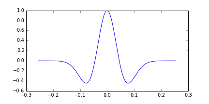
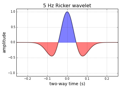
The Ricker wavelet represents an impulsive signal (the 'bang' of dynamite or the 'pop' of an airgun; let's leave Vibroseis out of it for now). The impulse is bandlimited ('band' as in radio band) — in other words, it doesn't contain all frequencies. Unfortunately, you need a lot of frequencies to represent very sudden or abrupt (short in time) things like bangs and pops, otherwise they spread out in time. Since our wavelet is restricted to a band of frequencies (eg 10 to 80 Hz), it must be (infinitely) spread out in time.

Additionally, since the frequencies don't contain what we call a 'DC' signal (0 Hz, in other words a bias or shift), it must return to zero when displaced. So it starts and ends on zero amplitude.

So the wavelet is spread out, and it starts and ends on zero amplitude. Why does it wiggle? In other words, why is seismic oscillatory? It's not the geophone: although it contains a spring (or something like one), its specially chosen/tuned to be able to move freely at the frequencies we're trying to record. So it's the stiffness of the earth itself which causes the oscillation, dissipating the vibrational energy (as heat) and damping the signal. At least, this explains why it dies out, but not really why it oscillates... Physics! Simple harmonic motion! Or something.

Yeah, I guess I’m a bit hazy on the micro-mechanics of wave propagation. Evan came to my rescue (see below), but I had a couple more things to say first:

The other thing is that classic wavelets like the Ricker are noncausal, aka non-realizable, because they have energy at negative time (i.e. they are centered around t = 0) and there’s no such thing as negative time. This is a clue that a zero-phase wavelet is a geological convenience contrived during processing, not a physical thing. The field seismic data would contain a so-called 'minimum phase' wavelet, which looks more like what you'd expect a recording of a dynamite blast to look like (see below).

To try to make up for the fact that I trailed off at ‘simple harmonic motion’, Evan offered this:

If you imagine the medium being made up of a bunch of particles, then propagating a wave means causing a stress (say, sudden compression at the surface) and then stretching and squeezing those particles to accommodate that stress. A compression (which we may measure or draw as a peak) does not come without a stretching (a dilation or trough) of particles on either side. So a side lobe (or a dilation) has to exist in a way: the particles are connected together and stretch and squeeze when they feel pressure.

Choice of wavelet matters

There was more from Doug McClymont, who’s always up for some chat about wavelets. He pointed out that although high-bandwidth Ormsby wavelets have more sidelobes, they generally have lower amplitudes than a Ricker wavelet, whose sidelobes always have the same ampitude (exactly \( 2 \mathrm{e}^{-3/2} \)). He added:

I tend not to use Ricker wavelets for very much as you can't control the bandwidth of them (just the peak frequency) so they tend to be very narrow-band and have quite high (and constant) amplitude side lobes. As I work a lot with broadband seismic data I use Ormsby wavelets much more for any well-ties and seismic modelling.

Good reasons to use an Ormsby wavelet as your analaytic wavelet of choice! Check out this other post all about Ormsby wavelets and how to make them.

What do you think? Do you have an intuitive explanation for why wavelets have sidelobes? Ideally shorter than mine!

Rocks in the Playground

It’s debatable whether neural networks should feature in an introductory course on machine learning. But it’s hard to avoid at least mentioning them, and many people are attracted to machine learning courses because they have heard so much about deep learning. So, reluctantly, we almost always get into neural nets in our Machine learning for geoscientists classes.

Our approach is to build a neural network from scratch, using only standard Python and NumPy data structures — that is, without using a specialist deep-learning framework. The code is all adapted from Gram Ganssle’s awesome Leading Edge tutorial from 2018. I like it because it lays out the components — the data, the activation function, the cost function, the forward pass, and all the steps involved in backpropagation — then combines them into a working neural network.

Figure 2 from Gram Ganssle’s 2018 tutorial in the Leading Edge. Licensed CC BY.

Figure 2 from Gram Ganssle’s 2018 tutorial in the Leading Edge. Licensed CC BY.

One drawback of our approach is that it would be quite fiddly to change some aspects of the network. For example, adding regularization, which almost all networks use, or even just adding another layer, are both beyond the scope of the class. So I like to follow it up with getting the students to build the same network using the scikit-learn library’s multilayer perceptron model. Then we build the same network using the PyTorch framework. (And one could do it in TensorFlow too, of course.) All of these libraries make it easier to play with the various options.

Introducing the Rocky Playground

Now we have another tool — one that makes it even easier to change parameters, add layers, use regularization, and so on. The students don’t even have to write any code! I invite you to play with it too — check out the Rocky Playground, an interactive deep neural network you can see inside.

Part of the user interface. Click on the image to visit the site.

Part of the user interface. Click on the image to visit the site.

This tool is a fork of Google’s well-known Neural Network Playground, as described at the bottom of our tool’s page. We made a few changes:

  • Added several new real and synthetic datasets, with descriptions.

  • There are more activation functions to try, including ELU and Swish.

  • You can change the regularization during training and watch the weights.

  • Anyone can upload their own dataset! (These stay on your computer, they are not uploaded anywhere.)

  • We added an the expression of the network in Python code.

One of the datasets we added is the same shear-sonic prediction dataset we use in the neural network class. So students can watch the same neural net they built (more or less) learn the task in real time. It’s really very cool.

I’ve written before about different expressions of mathematical ideas — words, symbols, annotations, code, etc. — and this is really just a natural extension of that thought. When people can hear and see the same idea in three — or five, or ten — different ways, it sticks. Or at least has a better chance of sticking.

What do you think? Do this tool help you? Could you use it for teaching? If you have suggestions feel free to drop them here in the comments, or submit an issue to the tool’s repo. We’d love your help to make it even more useful.

Looking forward to 2021

I usually write a ‘lookback’ at this time of year, but who wants to look back on 2#*0? Instead, let’s look forward to 2021 and speculate wildly about it!

More ways to help

Agile has always been small and nimble, but the price we pay is bandwidth: it’s hard to help all the people we want to help. But we’ve taught more than 1250 people Python and machine learning since 2018, and supporting this new community of programmers is our priority. Agile will be offering some new services in the new year, all aimed at helping you ‘just in time’ — what you need, when you need it — so that those little glitches don’t hold you up. The goal is to accelerate as many people as possible, but to be awesome value. Stay tuned!

We are still small, but we did add a new scientist to the team this year: Martin Bentley joined us. Martin is a recent MSc geology graduate from Nelson Mandela University in Port Elizabeth, South Africa. He’s also a very capable Python programmer and GIS wizard, as well as a great teacher, and he’s a familiar face around the Software Underground too.

Martin2.jpeg

All over the world

While we’ll be making ourselves available in new ways in 2021, we’ll continue our live classes too — but we’ll be teaching in more accessible ways and in more time zones. This year we taught 29 virtual classes for people based in Los Angeles, Calgary, Houston, Bogotá, Rio de Janeiro, Glasgow, London, Den Haag, Krakow, Lagos, Brunei, Muscat, Tunis, Kuala Lumpur, and Perth. Next year I want to add Anchorage, Buenos Aires, Durban, Reykjavik, Jakarta, and Wellington. The new virtual world has really driven home to me how inaccessible our classes and events were — we will do better!

Public classes appear here when we schedule them: https://agilescientific.com/training

Maximum accessibility

The event I’m most excited about is TRANSFORM 2021 (mark your calendar: 17 to 23 April!), the annual virtual meeting of the Software Underground. The society incorporated back in April, so it’s now officially a technical society. But it’s unlike most other technical societies in our domain: it’s free, and — so far anyway — it operates exclusively online. Like this year, the conference will focus on helping our community acquire new skills and connections for the future. Want to be part of it? Get notified.

april-2021-big.png

agile-open_star_600px.png

Thank you for reading our blog, following Agile, and being part of the digital subsurface community. If you’re experiencing uncertainty in your career, or in your personal life, I hope you’re able to take some time out to recharge over the next couple of weeks. We can take on 2021 together, and meet it head on — not with a plan, but with a purpose.

Feel superhuman: learning and teaching geocomputing

Diego teaching in Houston in 2018.

Diego teaching in Houston in 2018.

It’s five years since we started teaching Python to geoscientists. To be honest, it might have been premature. At the time, Evan and I were maybe only two years into serious, daily use of Python. But the first class, at the Atlantic Geological Society’s annual meeting in February 2014, was free so the pressure was not too high. And it turns out that only being a step or two ahead of your students can be an advantage. Your ‘expert blind spot’ is partially sighted not completely blind, because you can clearly remember being a noob.

Being a noob is a weird, sometimes very uncomfortable, even scary, feeling for some people. Many of us are used to feeling like experts, at least some of the time. Happy, feeling like a noob is a core competency in programming. Learning new things is a more or less hourly experience for coders. Even a mature language like Python evolves fast enough that it’s hard to keep up. Instead of feeling threatened or exhausted by this, I think the best strategy is to enjoy it. You’ll never be done, there are (way) more questions than answers, and you can learn forever!

One of the bootcamp groups at the Copenhagen hackathon in 2018

One of the bootcamp groups at the Copenhagen hackathon in 2018

This week we’re teaching our 40th course. Last year alone we gave digital superpowers to 325 people, mostly geoscientists, Not all of them learned to code, as such — some people already could, and some found out theydidn’t like it… coding really isn’t for everyone. But I think all of them learned something new about technology, and how it can serve them and their science. I hope all of them look at spreadsheets, and Petrel, and websites differently now. I think most of them want, at some point, to learn more. And everyone is excited about machine learning.

The expanding community of quantitative earth scientists

This year we’ve already spent 50 days teaching, and taught 174 people. Imagine that! I get emotional when I think about what these hundreds of new digital geoscientists and engineers will go and do with their new skills. I get really excited when I see what they are already doing — when they come to hackathons, send us screenshots, or write papers with beautiful figures. If the joy of sharing code and collaborating with peers has also rubbed off on them, there’s no telling where it could lead.

Matt teaching in Aberdeen in October 2018

Matt teaching in Aberdeen in October 2018

The last nine months or so have been an adventure. Teaching is not supposed to be what Agile is about. We’re a consulting company, a technology company. But for now we’re mostly a training company — it’s where we’re needed. And it makes sense... Programming is fundamentally about knowledge sharing. Teaching is about helping, collaborating. It’s perfect for us.

Besides, it’s a privilege and a thrill to meet all these fantastically smart, motivated people and to hear about their projects and their plans. Sometimes I wish it didn’t mean leaving my family in Nova Scotia and flying to Houston and London and Kuala Lumpur and Kalamazoo… but mostly I wish we could do more of it. Especially when we get comments like these:

Given how ‘dry’ programming can be, it was DYNAMIC.”
”Excellent teachers with geoscience background.”
”Great instructors, so so approachable, even for newbies like me.”
”Great course [...] Made me realize what could be done in a short time.”
”My only regret was not taking a class like this sooner.”
”Very positive, feel superhuman.

How many times have you felt superhuman at work recently?

The courses we teach are evolving and expanding in scope. But they all come back to the same thing: growing digital skills in our profession. This is critical because using computers for earth science is really hard. Why? The earth is weird. We’ve spent hundreds of years honing conceptual models, understanding deep time, and figuring out complex spatial relationships.

If data science eats the subsurface without us, we’re all going to get indigestion. Society needs to better understand the earth — for all sorts of reasons — and it’s our duty to build and adopt the most powerful analytical tools available so that we can help.


Learning resources

If you can’t wait to get started, here are some suggestions:

Classroom courses are a big investment in dollars and time, but they can get you a long way really quickly. Our courses are built especially for subsurface scientists and engineers. As far as I know, they are the only ones of their kind. If you think you’d like to take one, talk to us, or look out for a public course. You can find out more or sign up for email alerts here >> https://agilescientific.com/training/

Last thing: I suggest avoiding DataCamp, because of sexual misconduct by an executive, compounded by total inaction, dishonest obfuscation, and basically failing spectacularly. Even their own trainers have boycotted them. Steer clear.

To plot a wavelet

As I mentioned last time, a good starting point for geophysical computing is to write a mathematical function describing a seismic pulse. The IPython Notebook is designed to be used seamlessly with Matplotlib, which is nice because we can throw our function on graph and see if we were right. When you start your own notebook, type

ipython notebook --pylab inline

We'll make use of a few functions within NumPy, a workhorse to do the computational heavy-lifting, and Matplotlib, a plotting library.

import numpy as np
import matplotlib.pyplot as plt

Next, we can write some code that defines a function called ricker. It computes a Ricker wavelet for a range of discrete time-values t and dominant frequencies, f:

def ricker(f, length=0.512, dt=0.001):
    t = np.linspace(-length/2, (length-dt)/2, length/dt)
    y = (1.-2.*(np.pi**2)*(f**2)*(t**2))*np.exp(-(np.pi**2)*(f**2)*(t**2))
    return t, y

Here the function needs 3 input parameters; frequency, f, the length of time over which we want it to be defined, and the sample rate of the signal, dt. Calling the function returns two arrays, the time axis t, and the value of the function, y.

To create a 5 Hz Ricker wavelet, assign the value of 5 to the variable f, and pass it into the function like so,

f = 5
t, y = ricker (f)

To plot the result,

plt.plot(t, y)

But with a few more commands, we can improve the cosmetics,

plt.figure(figsize=(7,4))
plt.plot( t, y, lw=2, color='black', alpha=0.5)
plt.fill_between(t, y, 0,  y > 0.0, interpolate=False, hold=True, color='blue', alpha = 0.5)
plt.fill_between(t, y, 0, y < 0.0, interpolate=False, hold=True, color='red', alpha = 0.5)

# Axes configuration and settings (optional)
plt.title('%d Hz Ricker wavelet' %f, fontsize = 16 )
plt.xlabel( 'two-way time (s)', fontsize = 14)
plt.ylabel('amplitude', fontsize = 14)
plt.ylim((-1.1,1.1))
plt.xlim((min(t),max(t)))
plt.grid()
plt.show()

Next up, we'll make this wavelet interact with a model of the earth using some math. Let me know if you get this up and running on your own.

Let's do it

It's short notice, but I'll be in Calgary again early in the new year, and I will be running a one-day version of this new course. To start building your own tools, pick a date and sign up:

Eventbrite - Agile Geocomputing    Eventbrite - Agile Geocomputing

Review: First Steps in Seismic Interpretation

Thomas Martin is a first-year graduate student at Scripps Institution of Oceanography. He got bored of waiting for us to review the seismic interpretation books (we are tectonically slow sometimes) and offered to review some for us. Thank you, Thomas! He's just about to set off on a research cruise to the Canadian Arctic on USCGC Healy to collect CHIRP seismic reflection data and sediment cores.


Herron, D (2012). First Steps in Seismic Interpretation. Geophysical Monograph Series 16. Society of Exploration Geophysicists, Tulsa, OK. Print ISBN 978-156080280-8. Ebook DOI 10.1190/1.9781560802938. List price: USD62. Member price: USD49. Student price: USD39.20

As a graduate student, this book has become quite the resource for me. It gives a good handle on basic seismic properties, and provides a solid introduction. Some of the topics it covers are not typically discussed in a geoscience journal papers that use seismic reflection data (migration comes to mind). The table of contents gives an idea of the breadth:

  1. Introduction
  2. Seismic response
  3. Seismic attributes — including subsections on amplitude, coherence, and inversion
  4. Velocity — sonic logs, well velocity surveys, seismic velocities, anisotropy, and depth conversion
  5. Migration
  6. Resolution
  7. Correlation concepts — horizons and faults, multiples, pitfalls, automatic vs manual picking
  8. Correlation procedures — loop tying, jump correlations, visualization
  9. Data quality and management — keeping track of everything
  10. Other considerations — e.g. 4D seismic, uncertainty and risk, and ergonomics

One of the great things about this book is that it's designed to be light on math, so all levels of geoscientists can pick it up. I have found this book invaluable because it is a great bridge from the 'pure' geophysicist to the seismic interpreter, and can improve the dialogue between these two camps. Chapter 10 is 'leftover' subjects, but it is one of the most helpful in the book as it covers approximations, career development, and a fantastic section on time spent and value added.

The book covers a lot of ground but, with the book coming in at under 200 pages, nothing in detail — this is not meant to be the ultimate text for seismic interpretation. I think the book is a little light for nearly $40 plus shipping, however (student price; the list price is over $60). I would recommend it to graduate students or early career scientists with an interest in seismic data, across the full range of geoscience disciplines. The price for a student is high for a small paperback book under 200 pages, but the content is worth it.

If you liked this review please leave an encouraging comment for Thomas.

First class in India

I wrote this post yesterday morning, sitting in the Indira Ghandi International Airport in Delhi, India.

Where am I?

I'm in India. Some quick facts:

I met some of these recent graduates last week, in an experimental corporate training course. Cairn India has been running a presentation skills course for several years, provided by a local trainer called Yadhav Mehra. Yadhav is a demure, soft-spoken man, right up until he stands up in front of his students. Then he becomes a versatile actor and spontaneous stand-up, swerving with the confidence of a Delhi cab driver between poignant personal stories and hilarious what-not-to-do impressions. I’ve been on the receiving end of plenty of courses before, but Yadhav really made me see ‘training’ as a profession in itself, with skills and standards of its own. I am grateful for that.

How did I end up here?

Serendipity is a wonderful thing. Last fall, Susan Eaton—whom I’d met in the pub after teaching for the first time—wrote a nice piece about my then-new writing course. One of my long-lost PhD supervisors, Stuart Burley, read this article in his office at Cairn India in Delhi, and it triggered a thought. He had Yadhav, a pro trainer, helping his super-bright geoscience and engineering grads with their presentation skills, but they also needed coaching in writing. 

Their education provides them with...

the traditional written communication vernacular employed in the physical sciences, in which exposition is lengthily embellished with extraneous verbiage, and the passivum, or passive voice in its not uncommon appellation, is unfailingly and rigorously exercised.

You get my point. Stuart’s thought was: let’s do combine the two courses!

What happened?

The great thing about Stuart is that, along with breadth of experience and penetrating geological insight, he’s practical—he gets stuff done. (Like almost everything else in my dim-witted student days, I didn’t appreciate how valuable this was at the time.) So the three of us planned a 3-day course that combined my day's worth of writing coaching with Yadhav's two-day presentation course. Yadhav brought some didactic rigour, and I brought some technical depth. Like all collectable first edition, it had some rough edges, but it went beautifully. Students wrote an extended abstract for a conference paper on Tuesday, then presented their paper on Thursday—they made a great effort, and all did brilliantly.

I hope we run the course again—I'd love to see it reach its full potential. 

In the meantime, if you're interested in exploring ways to get more people in your organization writing a little better, or a little more often, do get in touch! You can find out more here. 

Rotten writing's rubbish, right?

Marked-up copy — effective copy editing is a useful skill for all scientists that writeI love teaching. I get a buzz from it. I don't know that I'm great at it, but I want to be great. As a student, I think I was quite reflective—both of my parents were teachers—and one of the great things about teaching is that you finally get to put your money where your mouth is. Every time you berated a teacher's boringness (behind their backs, obviously), or whined about how pointless an essay or lab exercise was (to your buddies), is now held up as a vivid and uncomfortable challenge. 

So late last year I got in touch with the Canadian Society of Petroleum Geologists (CSPG) and the US Society of Exploration Geophysicists (SEG) and offered a one-day short course. They both said they'd been wanting to offer something like it and, if enough people sign up for it, the course will run at least twice this year:

My worry is this: writing is like driving—most people think they're pretty good at it. But my course isn't just about style, it's also about tools, publishing, and getting things done. My two goals for the day are:

Get more people writing. Especially people from industry, who often excuse themselves from the global scientific community. 'I don't have the time' or 'My work's not interesting enough' are the things I hear. And maybe I'm a shallow, superficial kind of person, but I'm not so worried about high-brow, highly specialized, technical writing. There's plenty of that. I just want to see more grass-roots experience, stories, tutorials, field trip reports, how-to's, and what-I-did-at-the-weekend's. More community, in less traditional media.

Get people thinking about good style. Style has two aspects: the qualitative (what we might call interestingness) and the quantitative (correctness).  I don't claim to be the world's greatest writer myself, but I know what gets me good feedback in my work, and I have an eye for detail (did you notice the extra space back there? I did). I think there are two insidious notions out there about writing: science is serious business, and 'nit-picky' detail is not all that important. Both of these notions are nonsense.

If you were to take a writing skills course like this, what would you want to do or see? If you've done a course like this before and loved it (or not!), what can I learn from it? 

Apologies to Jon Agee for the title; his poem Rotten Writing, in his book Orangutan Tongs was the inspiration.