The map that changed the man

This is my contribution to the Accretionary Wedge geoblogfest, number 43: My Favourite Geological Illustration. You can read all about it, and see the full list of entries, at In the Company of Plants and Rocks. To quote Hollis:

All types of geological illustrations qualify — drawings, paintings, maps, charts, graphs, cross-sections, diagrams, etc., but not photographs.  You might choose something because of its impact, its beauty, its humor, its clear message or perhaps because of a special role it played in your life.  Let us know the reasons for your choice!

The map that changed the man

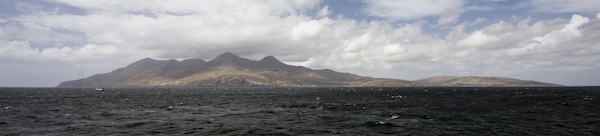
In 1987, at the age of 16, I became a geologist wannabe. A week on Rùm (called Rhum at the time) with volcanologist Steve Sparks convinced me that it was the most complete science of nature, being a satisfying stew of physics, chemistry, geomorphology, cosmology, fluid dynamics, and single malt whisky. One afternoon, he showed me cross-beds in the Torridonian sandstones on the shore of Loch Scresort, and identical cross-beds in the world-famous layered gabbros in the magma chamber of a Palaeogene volcano. 

View of Rum image by Southside Images, see below for credit.

But I was just a wannabe. So I studied hard at school and went off to the University of Durham. The usual studying and non-studying ensued, during which I discovered which parts of the science drew me in. There were awesome field trips, boring crystallography lectures, and tough structural geology labs. And at the end of the second year, there was the 6-week independent mapping project

As far as I know, independent mapping projects sensu stricto are a British phenomenon. I hope they still exist. Two groups decided the UK, while offering incredible basemaps and rich geological literature, was too soggy. One group went to the French Alps, where carbonates legend Maurice Tucker would be vacationing and available for advice, the other group decided that was too easy and went off to the wild mountains of northern Spain and the thrust front of the Pyrenees, where no-one was vacationing and no-one would be available for anything. Guess which group I was in. 

To say we were green would be like saying geologists think beer is OK. I hitchhiked there (but only had one creepy ride). We lived in tents (but in a peach orchard). It was July, and 35 degrees Celsius on a cool day (but there was a lake). We had no money (but lots of coloured pencils). It wasn't so bad. We all fell in love with Spain. 

Anyway, long story short, I made this map. It's no good, but that's not the point. It's my map. It's the map that turned me from wannabe into actual (if poor). It doesn't really need any commentary. It took hours and hours of scratching with Rotring Rapidographs on drawing film, then colouring the Diazo print by hand. This sounds like ancient history, but the methods I used to create it were already on the verge of extinction—the following year I started using Adobe Illustrator for draughting, and now I use Inkscape. And while some field tools have changed (of course we were not armed with laptops, Google Earth, GPS, or digital cameras), others are pure and true and timeless. Whack, whack,...

The ring of my hammer on Late Cretaceous limestones is still echoing through the Pyrenees. 

Geological map of the Embaase de Santa Ana, Alfarras, Spain; click to enlarge.

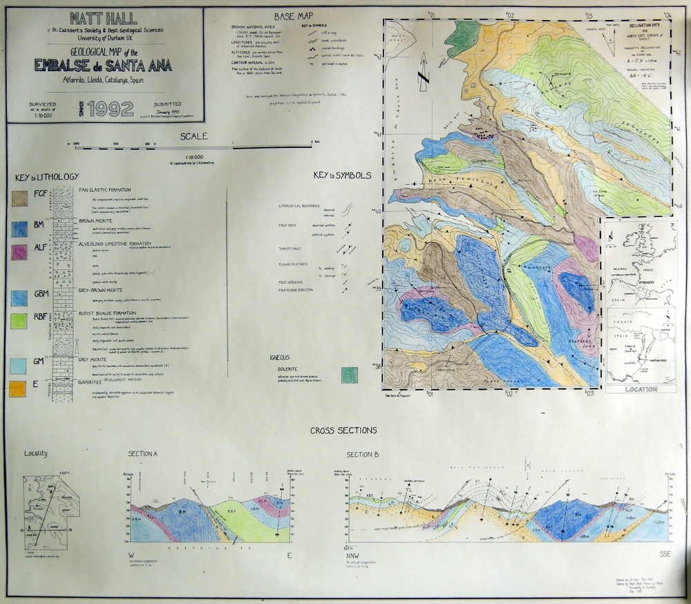
My map of the geology around the Embalse de Santa Ana. Hand-drawn by me in 1992, though I admit it looks like it's from 1892. Click for a larger view. View of Rùm by flickr user Southside Images, licensed CC-BY-NC-SA.

Please sir, may I have some processing products?

Just like your petrophysicist, your seismic processor has some awesome stuff that you want for your interpretation. She has velocities, fold maps, and loads of data. For some reason, processors almost never offer them up — you have to ask. Here is my processing product checklist:

A beautiful seismic volume to interpret. Of course you need a volume to tie to wells and pick horizons on. These days, you usually want a prestack time migration. Depth migration may or may not be something you want to pay for. But there's little point in stopping at poststack migration because if you ever want to do seismic analysis (like AVO for example), you're going to need a prestack time migration. The processor can smooth or enhance this volume if they want to (with your input, of course). 

Unfiltered, attribute-friendly data. Processors like to smooth things with filters like fxy and fk. They can make your data look nicer, and easier to pick. But they mix traces and smooth potentially important information out—they are filters after all. So always ask for the unfiltered data, and use it for attributes, especially for computing semblance and any kind of frequency-based attribute. You can always smooth the output if you want.

Limited-angle stacks. You may or may not want the migrated gathers too—sometimes these are noisy, and they can be cumbersome for non-specialists to manipulate. But limited-angle stacks are just like the full stack, except with fewer traces. If you did prestack migration they won't be expensive, get them exported while you have the processor's attention and your wallet open. Which angle ranges you ask for depends on your data and your needs, but get at least three volumes, and be careful when you get past about 35˚ of offset. 

Rich, informative headers. Ask to see the SEG-Y file header before the final files are generated. Ensure it contains all the information you need: acquisition basics, processing flow and parameters, replacement velocity, time datum, geometry details, and geographic coordinates and datums of the dataset. You will not regret this and the data loader will thank you.

Processing report. Often, they don't write this until they are finished, which is a shame. You might consider asking them to write up a shared Google Docs or a private wiki as they go. That way, you can ensure you stay engaged and informed, and can even help with the documentation. Make sure it includes all the acquisition parameters as well as all the processing decisions. Those who come after you need this information!

Parameter volumes. If you used any adaptive or spatially varying parameters, like anisotropy coefficients for example, make sure you have maps or volumes of these. Don't forget time-varying filters. Even if it was a simple function, get it exported as a volume. You can visualize it with the stacked data as part of your QC. Other parameters to ask for are offset and azimuth diversity.

Migration velocity field (get to know velocities). Ask for a SEG-Y volume, because then you can visualize it right away. It's a good idea to get the actual velocity functions as well, since they are just small text files. You may or may not use these for anything, but they can be helpful as part of an integrated velocity modeling effort, and for flagging potential overpressure. Use with care—these velocities are processing velocities, not earth measurements.

The SEG's salt model, with velocities. Image:Sandia National Labs.Surface elevation map. If you're on land, or the sea floor, this comes from the survey and should be very reliable. It's a nice thing to add to fancy 3D displays of your data. Ask for it in depth and in time. The elevations are often tucked away in the SEG-Y headers too—you may already have them.

Fold data. Ask for fold or trace density maps at important depths, or just get a cube of all the fold data. While not as illuminating as illumination maps, fold is nevertheless a useful thing to know and can help you make some nice displays. You should use this as part of your uncertainty analysis, especially if you are sending difficult interpretations on to geomodelers, for example. 

I bet I have missed something... is there anything you always ask for, or forget and then have to extract or generate yourself? What's on your checklist?

Bring it into time

A student competing in the AAPG's Imperial Barrel Award recently asked me how to take seismic data, and “bring it into depth”. How I read this was, “how do I take something that is outside my comfort zone, and make it fit with what is familiar?” Geologists fear the time domain. Geology is in depth, logs are in depth, drill pipe is in depth. Heck, even X and Y are in depth. Seismic data relates to none of those things; useless right? 

It is excusable for the under-initiated, but this concept of “bringing [time domain data] into depth” is an informal fallacy. Experienced geophysicists understand this because depth conversion, in all of its forms and derivatives, is a process that introduces a number of known unknowns. It is easier for others to be dismissive, or ignore these nuances. So early-onset discomfort with the travel-time domain ensues. It is easier to stick to a domain that doesn’t cause such mental backflips; a kind of temporal spatial comfort zone. 

Linear in time

However, the unconverted should find comfort in one property where the time domain is advantageous; it is linear. In contrast, many drillers and wireline engineers are quick to point that measured depth is not nessecarily linear. Perhaps time is an even more robust, more linear domain of measurement (if there is such a concept). And, as a convenient result, a world of possibilities emerge out of time-linearity: time-series analysis, digital signal processing, and computational mathematics. Repeatable and mechanical operations on data.

Boot camp in time

The depth domain isn’t exactly omnipotent. A colleague, who started her career as a wireline-engineer at Schlumberger, explained to me that her new-graduate training involved painfully long recitations and lecturing on the intricacies of depth. What is measured depth? What is true vertical depth? What is drill-pipe stretch? What is wireline stretch? And so on. Absolute depth is important, but even with seemingly rigid sections of solid steel drill pipe, it is still elusive. And if any measurement requires a correction, that measurement has error. So even working in the depth domain data has its peculiarities.

Few of us ever get the privilege of such rigorous training in the spread of depth measurements. Sitting on the back of the rhetorical wireline truck, watching the coax-cable unpeel into the wellhead. Few of us have lifted a 300 pound logging tool, to feel the force that it would impart on kilometres of cable. We are the recipients of measurements. Either it is a text file, or an image. It is what it is, and who are we to change it? What would an equvialent boot camp for travel-time look like? Is there one?

In the filtered earth, even the depth domain is plastic. Travel-time is the only absolute.

News of the week

Our regularly irregular news column returns! If you come across geoscience–tech tidbits, please drop us a line

A new wiki for geophysics

If you know Agile*, you know we like wikis, so this is big news. Very quietly, the SEG recently launched a new wiki, seeded with thousands of pages of content from Bob Sheriff's famous Encyclopedic Dictionary of Applied Geophysics. So far, it is not publicly editable, but the society is seeking contributors and editors, so if you're keen, get involved. 

On the subject of wikis, others are on the horizon: SPE and AAPG also have plans. Indeed members of SEG and AAPG were invited to take a survey on 'joint activities' this week. There's a clear opportunity for unity here — which was the original reason for starting our own subsurfwiki.org. The good news is that these systems are fully compatible, so whatever we build separately today can easily be integrated tomorrow. 

The DISC is coming

The SEG's Distinguished Instructor Short Course is in its 15th year and kicks off in 10 days in Brisbane. People rave about these courses, though I admit I felt like I'd been beaten about the head with the wave equation for seven hours after one of them (see if you can guess which one!). This year, the great Chris Liner (University of Houston prof and ex-editor of Geophysics) goes on the road with Elements of Seismic Dispersion: A somewhat practical guide to frequency-dependent phenomena. I'm desperate to attend, as frequency is one of my favourite subjects. You can view the latest schedule on Chris's awesome blog about geophysics, which you should bookmark immediately.

Broadband bionic eyes

Finally, a quirky story about human perception and bandwidth, both subjects close to Agile's core. Ex-US Air Force officer Alek Komar, suffering from a particularly deleterious cataract, had a $23k operation to replace the lens in one eye with a synthetic lens. One side-effect, apart from greater acuity of vision: he can now see into the ultraviolet.

If only it was that easy to get more high frequencies out of seismic data; the near-surface 'cataract' is not as easily excised.

This regular news feature is for information only. We aren't connected with any of these organizations, and don't necessarily endorse their products or services. 

More than a blueprint

blueprint_istock.jpg
"This company used to function just fine without any modeling."

My brother, an architect, paraphrased his supervisor this way one day; perhaps you have heard something similar. "But the construction industry is shifting," he noted. "Now, my boss needs to see things in 3D in order to understand. Which is why we have so many last minute changes in our projects. 'I had no idea that ceiling was so low, that high, that color, had so many lights,' and so on."

The geological modeling process is often an investment with the same goal. I am convinced that many are seduced by the appeal of an elegantly crafted digital design, the wow factor of 3D visualization. Seeing is believing, but in the case of the subsurface, seeing can be misleading.

Not your child's sandbox! Photo: R Weller.

Not your child's sandbox! Photo: R Weller.

Building a geological model is fundamentally different than building a blueprint, or at least it should be. First of all, a geomodel will never be as accurate as a blueprint, even after the last well has been drilled. The geomodel is more akin to the apparatus of an experiment; literally the sandbox and the sand. The real lure of a geomodel is to explore and evaluate uncertainty. I am ambivalent about compelling visualizations that drop out of geomodels, they partially stand in the way of this high potential. Perhaps they are too convincing.

I reckon most managers, drillers, completions folks, and many geoscientists are really only interested in a better blueprint. If that is the case, they are essentially behaving only as designers. That mindset drives a conflict any time the geomodel fails to predict future observations. A blueprint does not have space for uncertainty, it's not defined that way. A model, however, should have uncertainty and simplifying assumptions built right in.

Why are the narrow geological assumptions of the designer so widely accepted and in particular, so enthusiastically embraced by the industry? The neglect of science keeping up with technology is one factor. Our preference for simple and quickly understood explanations is another. Geology, in its wondrous complexity, does not conform to such easy reductions.

Despite popular belief, this is not a blueprint.We gravitate towards a single solution precisely because we are scared of the unknown. Treating uncertainty is more difficult that omitting it, and a range of solutions is somehow less marketable than precision (accuracy and precision are not the same thing). It is easier because if you have a blueprint, rigid, with tight constraints, you have relieved yourself from asking what if?

  • What if the fault throw was 20 m instead of 10 m?
  • What if the reservoir was oil instead of water?
  • What if the pore pressure increases downdip?

The geomodelling process should be undertaken for the promise of invoking questions. Subsurface geoscience is riddled with inherent uncertainties, uncertainties that we aren't even aware of. Maybe our software should have a steel-blue background turned on as default, instead of the traditional black, white, or gray. It might be a subconscious reminder that unless you are capturing uncertainty and iterating, you are only designing a blueprint.

If you have been involved with building a geologic model, was it a one-time rigid design, or an experimental sandbox of iteration?

The photograph of the extensional sandbox experiment is used with permission from Roger Weller of Cochise College. Image of geocellular model from the MATLAB Reservoir Simulation Toolbox (MRST) from SINTEF applied mathematics, which has been recently released under the terms of the GNU General public license! The blueprint is © nadla and licensed from iStock. None of these images are subject to Agile's license terms.

Open up

After a short trip to Houston, today I am heading to London, Ontario, for a visit with Professor Burns Cheadle at the University of Western Ontario. I’m stoked about the trip. On Saturday I’m running my still-developing course on writing for geoscientists, and tomorrow I’m giving the latest iteration of my talk on openness in geoscience. I’ll post a version of it here once I get some notes into the slides. What follows is based on the abstract I gave Burns.

A recent survey by APEGBC's Innovation magazine revealed that geoscience is not among the most highly respected professions. Only 20% of people surveyed had a ‘great deal of respect’ for geologists and geophysicists, compared to 30% for engineers, and 40% for teachers. This is far from a crisis, but as our profession struggles to meet energy demands, predict natural disasters, and understand environmental change, we must ask, How can we earn more trust? Perhaps more openness can help. I’m pretty sure it can’t hurt.

Many people first hear about ‘open’ in connection with software, but open software is just one point on the open compass. And even though open software is free, and can spread very easily in principle, awareness is a problem—open source marketing budgets are usually small. Open source widgets are great, but far more powerful are platforms and frameworks, because these allow geoscientists to focus on science, not software, and collaborate. Emerging open frameworks include OpendTect and GeoCraft for seismic interpretation, and SeaSeis and BotoSeis for seismic processing.

If open software is important for real science, then open data are equally vital because they promote reproducibility. Compared to the life sciences, where datasets like the Human Genome Project and Visible Human abound, the geosciences lag. In some cases, the pieces exist already in components like government well data, the Open Seismic Repository, and SEG’s list of open datasets, but they are not integrated or easy to find. In other cases, the data exist but are obscure and lack a simple portal. Some important plays, of global political and social as well as scientific interest, have little or no representation: industry should release integrated datasets from the Athabasca oil sands and a major shale gas play as soon as possible.

Open workflows are another point, because they allow us to accelerate learning, iteration, and failure, and thus advance more quickly. We can share easily but slowly and inefficiently by publishing, or attending meetings, but we can also write blogs, contribute to wikis, tweet, and exploit the power of the internet as a dynamic, multi-dimensional network, not just another publishing and consumption medium. Online readers respond, get engaged, and become creators, completing the feedback loop. The irony is that, in most organizations, it’s easier to share with the general public, and thus competitors, than it is to share with colleagues.

The fourth point of the compass is in our attitude. An open mindset recognizes our true competitive strengths, which typically are not our software, our data, or our workflows. Inevitably there are things we cannot share, but there’s far more that we can. Industry has already started with low-risk topics for which sharing may be to our common advantage—for example safety, or the environment. The question is, can we broaden the scope, especially to the subsurface, and make openness the default, always asking, is there any reason why I shouldn’t share this?

In learning to embrace openness, it’s important to avoid some common misconceptions. For example, open does not necessarily mean free-as-in-beer. It does not require relinquishing ownership or rights, and it is certainly not the same as public domain. We must also educate ourselves so that we understand the consequences of subtle and innocuous-seeming clauses in licences, for example those pertaining to non-commerciality. If we can be as adept in this new language as many of us are today in intellectual property law, say, then I believe we can accelerate innovation in energy and build trust among our public stakeholders.

So what are you waiting for? Open up!

Stop waiting for permission to knock someone's socks off

When I had a normal job, this was the time of year when we set our goals for the coming months. Actually, we sometimes didn't do it till March. Then we'd have the end-of-year review in October... Anyway, when I thought of this, it made me think about my own goals for the year, for Agile, and my career (if you can call it that). Here's my list:

1. Knock someone's socks off.

That's it. That's my goal. I know it's completely stupid. It's not SMART: specific, measurable, attainable, realistic, or timely. I don't believe in SMART. For a start, it's obviously a backronym. That's why there's attainable and realistic in there—what's the difference? They're equally depressing and uninspiring. Measurable, attainable goals are easy, and I'm going to do them anyway: it's called work. It's the corporate equivalent of saying my goals for the day are waking up, getting out of bed, having a shower, making a list of attainable goals... Maybe those are goals if you're in rehab, but if you're a person with a job or a family they're just part of being a person.

I don't mean we should not make plans and share lists of tasks to help get stuff done. It's important to have everyone working at least occasionally in concert. In my experience people tend to do this anyway, but there's no harm in writing them down for everyone to see. Managers can handle this, and everyone should read them.

Why do these goals seem so dry? You love geoscience or engineering or whatever you do. That's a given. (If you don't, for goodness's sake save yourself.) But people keep making you do boring stuff that you don't like or aren't much good at and there's no time left for the awesomeness you are ready to unleash, if only there was more time, if someone would just ask. 

Stop thinking like this. 

You are not paid to be at work, or really to do your job. Your line manager might think this way, because that's how hierarchical management works: it's essentially a system of passing goals and responsiblities down to the workforce. A nameless, interchangeable workforce. But what the executives and shareholders of your company really want from you, what they really pay you for, is Something Amazing. They don't know what it is, or what you're capable of — that's your job. Your job is to systematically hunt and break and try and build until you find the golden insight, the new play, the better way. The real challenge is how you fit the boring stuff alongside this, not the other way around.

Knock someone's socks off, then knock them back on again with these seismic beauties.Few managers will ever come to you and say, "If you think there's something around here you can transform into the most awesome thing I've ever seen, go ahead and spend some time on it." You will never get permission to take risks, commit to something daring, and enjoy yourself. But secretly, everyone around you is dying to have their socks knocked right off. Every day they sadly go home with their socks firmly on: nothing awesome today.

I guarantee that, in the process of trying to do something no-one has ever done or thought of before, you will still get the boring bits of your job done. The irony is that no-one will notice, because they're blinded by the awesome thing no-one asked you for. And their socks have been knocked off.