100 years of seismic reflection

Where would we be without seismic reflection? Is there a remote sensing technology that is as unlikely, as difficult, or as magical as the seismic reflection method? OK, maybe neutrino tomography. But anyway, seismic has contributed a great deal to society — helping us discover and describe hydrocarbon resources, aquifers, geothermal anomalies, sea-floor hazards, and plenty more besides.

It even indirectly led to the integrated circuit, but that’s another story.

Depending on who you ask, 9 August 2021 may or may not be the 100th anniversary of the seismic reflection method. Or maybe 5th August. Or maybe it was June or July. But there’s no doubt that, although the first discovery with seismic did not happen until several years later, 1921 was the year that the seismic reflection method was invented.

Ryan, Karcher and Haseman in the field, August 1921. Badly colourized by an AI.

Ryan, Karcher and Haseman in the field, August 1921. Badly colourized by an AI.

The timeline

I’ve tried to put together a timeline by scouring a few sources. Several people — Clarence Karcher (a physicist), William Haseman (a physicist), Irving Perrine (a geologist), William Kite (a geologist) at the University of Oklahoma, and later Daniel Ohern (a geologist) — conducted the following experiments:

  • 12 April 1919 — Karcher recorded the first exploration seismograph record near the National Bureau of Standards (now NIST) in Washington, DC.

  • 1919 to 1920 — Karcher continues his experimentation.

  • April 1921 — Karcher, whilst working at the National Bureau of Standards in Washington, DC, designed and constructed apparatus for recording seismic reflections.

  • 4 June 1921 — the first field tests of the refleciton seismograph at Belle Isle, Oklahoma City, using a dynamite source.

  • 6 June until early July — various profiles were acquired at different offsets and spacings.

  • 14 July 1921 — Testing in the Arbuckle Mountains. The team of Karcher, Haseman, Ohern and Perrine determined the velocities of the Hunton limestone, Sylvan shale, and Viola limestone.

  • Early August 1921 — The group moves to Vines Branch where “the world’s first reflection seismograph geologic section was measured”, according to a commemorative plaque on I-35 in Oklahoma. That plaque claims it was 9 August, but there are also records from 5 August. The depth to the Viola limestone is recorded and observed to change with geological structure.

  • 1 September 1921 — Karcher, Haseman, and Rex Ryan (a geologist) conduct experiments at the Newkirk Anticline near Ponca City.

  • 13 September 1921 — a survey was begun for Marland Oil Company and continues into October. Success seems mixed.

So what did these physicists and geologists actually do? Here’s an explanation from Bill Dragoset in his excellent review of the history of seismic from 2005:

Using a dynamite charge as a seismic source and a special instrument called a seismograph, the team recorded seismic waves that had traveled through the subsurface of the earth. Analysis of the recorded data showed that seismic reflections from a boundary between two underground rock layers had been detected. Further analysis of the data produced an image of the subsurface—called a seismic reflection profile—that agreed with a known geologic feature. That result is widely regarded as the first proof that an accurate image of the earth’s subsurface could be made using reflected seismic waves.
— Bill Dragoset, A Historical Reflection on Reflections

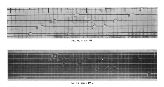
The data was a bit hard to interpret! This is from William Schriever’s paper:

Marland_seismic.png

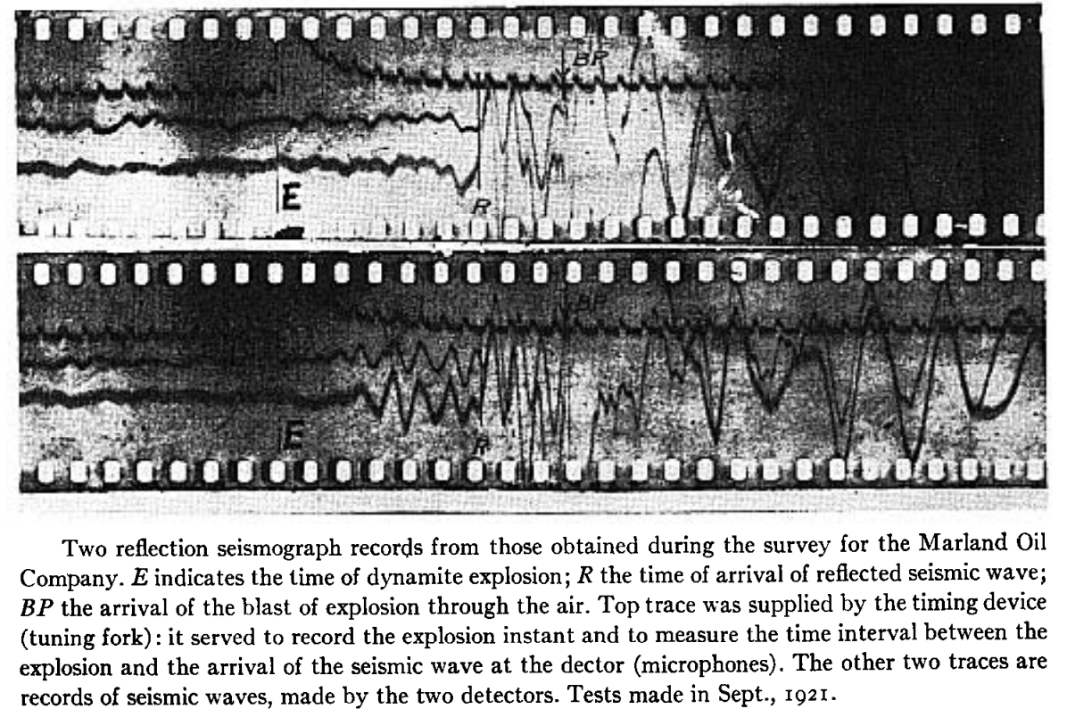
Nonetheless, here’s the section the team managed to draw at Vine Creek. This is the world’s first reflection seismograph section — 9 August 1921:

The method took a few years to catch on — and at least a few years to be credited with a discovery. Karcher founded Geophysical Research Corporation (now Sercel) in 1925, then left and founded Geophysical Service International — which later spun out Texas Instruments — in 1930. And, eventually, seismic reflection turned into an idsutry worth tens of billions of dollars per year. Sometimes.

References

Bill Dragoset, (2005), A historical reflection on reflections, The Leading Edge 24: s46-s70. https://doi.org/10.1190/1.2112392

Clarence Karcher (1932). DETERMINATION OF .SUBSURFACE FORMATIONS. Patent no. 1843725A. Patented 2 Feb 1932.

William Schriever (1952). Reflection seismograph prospecting; how it started; contributions. Geophysics 17 (4): 936–942. doi: https://doi.org/10.1190/1.1437831

B Wells and K Wells (2013). American Oil & Gas Historical Society. American Oil & Gas Historical Society. Exploring Seismic Waves. Last Updated: August 7, 2021. Original Published Date: April 29, 2013.

Productive chaos

Wednesday was a good day.

Over 150 participants came to Room 251 for all or part of the first 'unsession' at the AAPG Annual Conference and Exhibition in Salt Lake City. I was one of the hosts of the event, and emceed the afternoon.

In a nutshell, it was awesome. I have facilitated unsessions before, but this event was on a new scale. Twelve tables of 8–10 seats — covered in sticky notes, stickers, coloured pens, and large sheets of paper — quickly filled up. Together, we burned about 10 person-weeks of human productivity, raising the temperature in the room by several degrees in the process.

Diversity means good conversation

On the way in, people self-identified as mostly software (blue name tags) or mostly soft rocks (red), as a non-serious way to get a handle on how many data scientists we had vs how many people are focused on the rocks themselves — without, I hope, any kind of value judgment. The ratio was about 1:2.

As people continued to drift in, we counted people identifying with various categories, to get a very rough idea of who was in the room. The results are shown here. In addition, I counted 24 women present at the start. Part of the point here is to introduce participants to each other, but there's another purpose too. AAPG, like many scientific organizations, is grappling with diversity today. Like others, it needs to do much better. A small part of the solution is, I think, to name it and measure how we're doing at every opportunity. It's one way to pay more attention.

Harder to capture is the profound level of job diversity. People responsible for billion-dollar budgets sat with graduate students, AAPG medal winners with SEC executives. We even had a venture capitalist and a physician.

Look at all these lovely people:

Tangible and intangible output

At the start of the session, I told the room I wanted to fill the walls with things we made — with data. We easily achieved this, producing a survey of the skills geoscientists will need in the future, hundreds of high-value machine learning tasks in geoscience, a ranked list of the most interesting of these, and even some problem analysis of some of them. None of this was definitive, but I hope it will provide grist for the mill of future conversations about machine learning in geoscience.

As well as these tangible products, each person in the room walked away with new connections and new ideas — about machine learning, about collaboration, and about what scientific meetings can be like.

Acknowledgments

A lot of people contributed to making this event happen.

My unsession co-chairs, Brendon Hall and Yan Zaretskiy of Enthought — spent several hours on the phone with me over the last few weeks, shaping the content and flow of an event that was a bit, er, fuzzy.

We seeded the tables with some of the Software Underground crowd who were in town for the hackathon and AAPG. This ensures that there's no failure case: twelve people are definitely coming. And in the unlikely event that 100 people come, there are twelve allies to manage some of the chaos. Heartfelt thanks to the table hosts:

  • Didi Ooi of the University of Bristol
  • Graham Ganssle of Expero
  • Lisa Stright of Colorado State University
  • Thomas Martin of Colorado School of Mines
  • Tom Creech of ExxonMobil
  • David Holmes of Dell EMC
  • Steve Purves of Euclidity
  • Diego Castaneda of Agile
  • Evan Bianco of Agile

Jenny Cole of SEG came along to observe the session and I appreciated her enthusiastic help as it became clear we were in for more than the usual amount of entropy in the room. Theresa Curry of AAPG did an amazing job getting the venue set up, providing refreshments, and ensuring the photographers were there to capture some of the action. The ACE 2018 organizing committee, especially Zane Jobe and Lauren Birgenheier, did their part by agreeing to supprt including such a weird-sounding thing in the program.

Finally, thank you to the 100+ scientists that came to the event, not knowing at all what to expect. It was a privilege to receive your enthusiastic participation and thoughtful contributions. Let's do it again some time!


We will digitize the ideas and products of the unsession over the coming weeks. They will be released under an open license. Watch this space for updates.

If you're interested in the methodology we use for these events, check out Proceedings of an unsession in CSEG Recorder, November 2013. If you'd like help running an event like this, get in touch.

Finding Big Bertha with a hot wire

mcnaughton-canada-war-museum.jpg

Sunday will be the 131st birthday of General Andrew McNaughton, a Canadian electrical engineer who served in the Canadian Expeditionary Force in the First World War. He was eventually appointed commander of the Canadian Corps Heavy Artillery and went on to serve in the Second World War as well.

So what is a professional soldier doing on a blog about geoscience? Well, McNaughton was part of the revolution of applied acoustics and geophysics that emerged right before and after the First World War.

Along with eminent British physicist Lawrence Bragg, engineer William Sansome Tucker, and physicist Charles Galton Darwin (the other Charles Darwin's grandson), among others, McNaughton applied physics to the big problem of finding the big noisy things that were trying to blow everyone up. They were involved in an arms race of their own — German surveyor Ludger Mintrop was trying to achieve the same goal from the other side of the trenches.

Big_Bertha.jpg

After gaining experience as a gunner, McNaughton became one of a handful of scientists and engineers involved in counter-battery operations. Using novel ranging techniques, these scientists gave the allied forces a substantial advantage over the enemy. Counter-battery fire became an weapon at pivotal battles like Vimy Ridge, and certainly helped expedite the end of the war.

If all this sounds like a marginal way to win a battle, stop think for a second about these artillery. The German howitzer, known as 'Big Bertha' (left), could toss an 820 kg (1800 lb) shell about 12.5 km (7.8 miles). In other words, it was incredibly annoying.


Combining technologies

Localization accuracy on the order of 5–10 m on the large majority of gun positions was eventually achieved by the coordinated use of several technologies, including espionage, cartography, aerial reconnaissance photography, and the new counter-measures of flash spotting and sound ranging.

Flash spotting was more or less just what it sounds like: teams of spotters recording the azimuth of artillery flashes, then triangulating artillery positions from multiple observations. The only real trick was in reporting the timing of flashes to help establish that the flashes came from the same gun.

Sound ranging, on the other hand, is a tad more complicated. It seems that Lawrence Bragg was the first to realize that the low frequency sound of artillery fire — which he said lifted him off the privy seat in the outhouse at his lodgings — might be a useful signal. However, microphones were not up to the task of detecting such low frequencies. Furthermore, the signal was masked by the (audible) sonic boom of the shell, as well as the shockwaves of passing shells.

Elsewhere in Belgium, William Tucker had another revelation. Lying inside a shack with holes in its walls, he realized that the 20 Hz pressure wave from the gun created tiny puffs of air through the holes. So he looked for a way to detect this pulse, and came up with a heated platinum wire in a rum jar. The filament's resistance dropped when cooled by the wavefront's arrival through an aperture. The wire was unaffected by the high-frequency shell wave. Later, moving-coil 'microphones' (geophones, essentially) were also used, as well as calibration for wind and temperature. The receivers were coupled with a 5-channel string galvanometer, invented by French engineers, to record traces onto 35-mm film bearing timing marks:

sound-ranging-traces.png

McNaughton continued to develop these technologies through the war, and by the end was successfully locating the large majority of enemy artillery locations, and was even able to specify the calibre of the guns and their probable intended targets. Erster Generalquartiermeister Erich Ludendorff commented at one point in the war: 

According to a captured English document the English have a well- developed system of sound-ranging which in theory corresponds to our own. Precautions are accordingly to be taken to camouflage the sound: e.g. registration when the wind is contrary, and when there is considerable artillery activity, many batteries firing at the same time, simultaneous firing from false positions, etc.

An acoustic arsenal

Denge_acoustic_mirrors_March-2005_Paul-Russon.jpg

The hot-wire artillery detector was not Tucker's only acoustic innovation. He also pioneered the use of acoustic mirrors for aircraft detection. Several of these were built around the UK's east coast, starting around 1915 — the three shown here are at Denge in Kent. They were rendered obselete by the invention of radar around the beginning of World War Two.

Acoustic and seismic devices are still used today in military and security applications, though they are rarely mentioned in applied geophysics textbooks. If you know about any interesting contemporary uses, tell us about it in the comments.


According to Crown Copyright terms, the image of McNaughton is out of copyright. The acoustic mirror image is by Paul Russon, licensed CC-BY-SA. The uncredited/unlicensed galvanometer trace is from the excellent Stop, hey, what's that sound article on the geographical imaginations blog; I assume it is out of copyright. The howitzer image is out of copyright.

This post on Target acquisition and counter battery is very informative and has lots of technical details, though most of it pertains to later technology. The Boom! Sounding out the enemy article on ScienceNews for Students is also very nice, with lots of images. 

Unearthing gold in Toronto

I just got home from Toronto, the mining capital of the world, after an awesome weekend hacking with Diego Castañeda, a recent PhD grad in astrophysics that is working with us) and Anneya Golob (another astrophysicist and Diego's partner). Given how much I bang on about hackathons, it might surprise you to know that this was the first hackathon I have properly participated in, without having to order tacos or run out for more beer every couple of hours.

PArticipants being briefed by one of the problem sponsors on the first evening.

PArticipants being briefed by one of the problem sponsors on the first evening.

What on earth is Unearthed?

The event (read about it) was part of a global series of hackathons organized by Unearthed Solutions, a deservedly well-funded non-profit based in Australia that is seeking to disrupt every single thing in the natural resources sector. This was their fourteenth event, but their first in Canada. Remarkably, they got 60 or 70 hackers together for the event, which I know from my experience organizing events takes a substantial amount of work. Avid readers might remember us mentioning them before, especially in a guest post by Jelena Markov and Tom Horrocks in 2014.

A key part of Unearthed's strategy is to engage operating companies in the events. Going far beyond mere sponsorship, Barrick Gold sent several mentors to the event, the Chief Innovation Officer Michelle Ash, as well as two judges, Ed Humphries (head of digital transformation) and Iain Allen (head of digital mining). Barrick provided the chellenge themes, as well as data and vivid descriptions of operational challenges. The company was incredibly candid with the participants, and should be applauded for its support of what must have felt like a pretty wild idea. 

Team Auger Effect: Diego and Anneya hacking away on Day 2.

Team Auger Effect: Diego and Anneya hacking away on Day 2.

What went down?

It's hard to describe a hackathon to someone who hasn't been to one. It's like trying to describe the Grand Canyon, ice climbing, or a 1985 Viña Tondonia Rioja. It's always fun to see and hear the reactions of the judges and other observers that come for the demos in the last hours of the event: disbelief at what small groups of humans can do in a weekend, for little tangible reward. It flies in the face of everything you think you know about creativity, productivity, motivation, and collaboration. Not to mention intellectual property.

As the fifteen (!) teams made their final 5-minute pitches, it was clear that every single one of them had created something unique and useful. The judges seemed genuinely blown away by the level of accomplishment. It's hard to capture the variety, but I'll have a go with a non-comprehensive list. First, there was a challenge around learning from geoscience data:

  • BGC Engineering, one of the few pro teams and First Place winner, produced an impressive set of tools for scraping and analysing public geoscience data. I think it was a suite of desktop tools rather than a web application.
  • Mango (winners of the Young Innovators award), Smart Miner (second place overall), Crater Crew, Aureka, and Notifyer and others presented map-based browsers for public mining data, with assistance from varying degrees of machine intelligence.
  • Auger Effect (me, Diego, and Anneya) built a three-component system consisting of a browser plugin, an AI pipeline, and a social web app, for gathering, geolocating, and organizing data sources from people as they research.

The other challenge was around predictive maintenance:

  • Tyrelyze, recognizing that two people a year are killed by tyre failures, created a concept for laser scanning haul truck tyres during operations. These guys build laser scanners for core, and definitely knew what they were doing.
  • Decelerator (winners of the People's Choice award) created a concept for monitoring haul truck driving behaviour, to flag potentially expensive driving habits.
  • Snapfix.io looked at inventory management for mine equipment maintenance shops.
  • Arcana, Leo & Zhao, and others looked at various other ways of capturing maintenance and performace data from mining equipment, and used various strategies to try to predict 

I will try to write some more about the thing we built... and maybe try to get it working again! The event was immensely fun, and I'm so glad we went. We learned a huge amount about mining too, which was eye-opening. Massive thanks to Unearthed and to Barrick on all fronts. We'll be back!

Brad BEchtold of Cisco (left) presenting the Young Innovator award for under-25s to Team Mango.

The winners of the People's Choice Award, Team Decelerate.

The winners of the contest component of the event, BGC Engineering, with Ed Humphries of Barrick (left).


UPDATE  View all the results and submissions from the event.


Wish there was a hackathon just for geoscientists and subsurface engineers?
You're in luck! Join us in Paris for the Subsurface Hackathon — sponsored by Dell EMC, Total E&P, NVIDIA, Teradata, and Sandstone. The theme is machine learning, and registration is open. There's even a bootcamp for anyone who'd like to pick up some skills before the hack.

PRESS START

The dust has settled from the Subsurface Hackathon 2016 in Vienna, which coincided with EAGE's 78th Conference and Exhibition (some highlights). This post builds on last week's quick summary with more detailed descriptions of the teams and what they worked on. If you want to contact any of the teams, you should be able to track them down via the links to Twitter and/or GitHub.

A word before I launch into the projects. None of the participants had built a game before. Many were relatively new to programming — completely new in one or two cases. Most of the teams were made up of people who had never worked together on a project before; indeed, several team mates had never met before. So get ready to be impressed, maybe even amazed, at what members of our professional community can do in 2 days with only mild provocation and a few snacks.

Traptris

An 8-bit-style video game, complete with music, combining Tetris with basin modeling.

Team: Chris Hamer, Emma Blott, Natt Turner (all MSc students at the University of Leeds), Jesper Dramsch (PhD student, Technical University of Denmark, Copenhagen). GitHub repo.

Tech: Python, with PyGame.

Details: The game is just like Tetris, except that the blocks have lithologies: source, reservoir, and seal. As you complete a row, it disappears, as usual. But in this game, the row reappears on a geological cross-section beside the main game. By completing further rows with just-right combinations of lithologies, you build an earth model. When it's deep enough, and if you've placed sources rocks in the model, the kitchen starts to produce hydrocarbons. These migrate if they can, and are eventually trapped — if you've managed to build a trap, that is. The team impressed the judges with their solid gamplay and boisterous team spirit. Just installing PyGame and building some working code was an impressive feat for the least experienced team of the hackathon.

Prize: We rewarded this rambunctious team for their creative idea, which it's hard to imagine any other set of human beings coming up with. They won Samsung Gear VR headsets, so I'm looking forward to the AR version of the game.

Flappy Trace

A ridiculously addictive seismic interpretation game. "So seismic, much geology".

Team: Håvard Bjerke (Roxar, Oslo), Dario Bendeck (MSc student, Leeds), and Lukas Mosser (PhD student, Imperial College London).

Tech: Python, with PyGame. GitHub repo.

Details: You start with a trace on the left of the screen. More traces arrive, slowly at first, from the right. The controls move the approaching trace up and down, and the pick point is set as it moves across the current trace and off the screen. Gradually, an interpretation is built up. It's like trying to fly along a seismic horizon, one trace at a time. The catch is that the better you get, the faster it goes. All the while, encouragements and admonishments flash up, with images of the doge meme. Just watching someone else play is weirdly mesmerizing.

Prize: The judges wanted to recognize this team for creating such a dynamic, addictive game with real personality. They won DIY Gamer kits and an awesome book on programming Minecraft with Python.

Guess What!

Human seismic inversion. The player must guess the geology that produces a given trace.

Team: Henrique Bueno dos Santos, Carlos Andre (both UNICAMP, Sao Paolo), and Steve Purves (Euclidity, Spain)

Tech: Python web application, on Flask. It even used Agile's nascent geo-plotting library, g3.js, which I am pretty excited about. GitHub repo. You can even play the game online!

Details: This project was on a list of ideas we crowdsourced from the Software Underground Slack, and I really hoped someone would give it a try. The team consisted of a postdoc, a PhD student, and a professional developer, so it's no surprise that they managed a nice implementation. The player is presented with a synthetic seismic trace and must place reflection coefficients that will, she hopes, forward model to match the trace. She may see how she's progressing only a limited number of times before submitting her final answer, which receives a score. There are so many ways to control the game play here, I think there's a lot of scope for this one.

Prize: This team impressed everyone with the far-reaching implications of the game — and the rich possibilities for the future. They were rewarded with SparkFun Digital Sandboxes and a copy of The Thrilling Adventures of Lovelace and Babbage.

DiamondChaser

aka DiamonChaser (sic). A time- and budget-constrained drilling simulator aimed at younger players.

Team: Paul Gabriel, Björn Wieczoreck, Daniel Buse, Georg Semmler, and Jan Gietzel (all at GiGa infosystems, Freiberg)

Tech: TypeScript, which compiles to JS. BitBucket repo. You can play the game online too!

Details: This tight-knit group of colleagues — all professional developers, but using unfamiliar technology — produced an incredibly polished app for the demo. The player is presented with a blank cross section, and some money. After choosing what kind of drill bit to start with, the drilling begins and the subsurface is gradually revealed. The game is then a race against the clock and the ever-diminishing funds, as diamonds and other bonuses are picked up along the way. The team used geological models from various German geological surveys for the subsurface, adding a bit of realism.

Prize: Everyone was impressed with the careful design and polish of the app this team created, and the quiet industry they brought to the event. They each won a CellAssist OBD2 device and a copy of Charles Petzold's Code.

Some of the participants waiting for the judges to finish their deliberations. Standing, from left: Håvard Bjerke, Henrique Bueno dos Santos, Steve Purves. Seated: Jesper Dramsch, Lukas Mosser, Natt Turner, Emma Blott, Dario Bendeck, Carlos André, B…

Some of the participants waiting for the judges to finish their deliberations. Standing, from left: Håvard Bjerke, Henrique Bueno dos Santos, Steve Purves. Seated: Jesper Dramsch, Lukas Mosser, Natt Turner, Emma Blott, Dario Bendeck, Carlos André, Björn Wieczoreck, Paul Gabriel.

Credits and acknowledgments

Thank you to all the hackers for stepping into the unknown and coming along to the event. I think it was everyone's first hackathon. It was an honour to meet everyone. Special thanks to Jesper Dramsch for all the help on the organizational side, and to Dragan Brankovic for taking care of the photography.

The Impact HUB Vienna was a terrific venue, providing us with multiple event spaces and plenty of room to spread out. HUB hosts Steliana and Laschandre were a great help. Der Mann produced the breakfasts. Il Mare pizzeria provided lunch on Saturday, and Maschu Maschu on Sunday.

Thank you to Kristofer Tingdahl, CEO of dGB Earth Sciences and a highly technical, as well as thoughtful, geoscientist. He graciously agreed to act as a judge for the demos, and I think he was most impressed with the quality of the teams' projects.

Last but far from least, a huge Thank You to the sponsor of the event, EMC, the cloud computing firm that was acquired by Dell late last year. David Holmes, the company's CTO (Energy) was also a judge, making an amazing opportunity for the hackers to show off their skills, and sense of humour, to a progressive company with big plans for our industry.

What now?

Times are rock hard in industry right now.

If you have a job, you're lucky — you have probably already survived one round of layoffs. There will likely be more, especially when the takeovers start, which they will. I hope you survive those too. 

If you don't have a job, you probably feel horrible, but of course that won't get you anywhere. I heard one person call it an 'involuntary sabbatical', and I love that: it's the best chance you'll get to re-invent, re-learn, and find new direction. 

If you're a student, you must be looking out over the wasteland and wondering what's in store for you. What on earth?

More than one person has asked me recently about Agile. "You got out," they say, "how did you do it?" So instead of bashing out another email, I thought I'd blog about it.

Consulting in 2015

I didn't really get out, of course, I just quit and moved to rural Nova Scotia.

Living out here does make it harder to make a living, and things on this side of the fence, so to speak, are pretty gross too I'm afraid. Talking to others at SEG suggested that I'm not alone among small companies in this view. A few of the larger outfits seem to be doing well: IKON and GeoTeric for instance, but they also have product, which at least offers some income diversity. 

Agile started as a 100% bootstrapped effort to be a consulting firm that's more directly useful to individual professional geoscientists than anyone else. Most firms target corporate accounts and require permission, a complicated contract, an AFE, and 3 months of bureaucracy to hire. It turns out that professionals are unable or unwilling to engage on that lower, grass-roots level, though — turns out almost everyone thinks you actually need permission, contracts, AFEs, etc, to get hired in any capacity, even just "Help me tie this well." So usually we are hired into larger, longer-term projects, just like anyone else.

I still think there's something in this original idea — the Uberification of consulting services, if you will — maybe we'll try again in a few years.

But if you are out of work and were thinking of getting out there as a consultant... I'm an optimistic person, but unless you are very well known (for being awesome), it's hard for me to honestly recommend even trying. It's just not the reality right now. We've been lucky so far, because we work in geothermal and government as well as in petroleum, but oil & gas was over half our revenue last year. It will be about 0% of it this year, maybe slightly less.

The transformation of Agile

All of which is to explain why we are now, since January, consciously and deliberately turning ourselves into a software technology R&D company. The idea is to be less dependent on our dysfunctional industry, and less dependent on geotechnical work. We build new tools for hard problems — data problems, interpretation problems, knowledge sharing problems. And we're really good at it.

We hired another brilliant programmer in August, and we're all learning more every day about our playground of scientific computing and the web — machine learning, cloud services, JavaScript frameworks, etc. The first thing we built was modelr.io, which is still in active development. Our latest project is around our tool pickthis.io. I hope it works out because it's the most fun I've had on a project in ages. Maybe these projects spin out of Agile, maybe we keep them in-house.

So that's our survival plan: invent, diversify, and re-tool like crazy. And keep blogging.

F**k it

Some people are saying, "things will recover, sit it out" but I think that's awful — the very worst — advice. I honestly think your best bet right now* is to find an accomplice, set aside 6 months and some of your savings, push everything off your desk, and do something totally audacious. 

Something you can't believe no-one has thought of doing yet.

Whatever it was you just thought of — that's the thing.

You might as well get started.


* Unless you have just retired, are very well connected in industry, have some free time, and want to start a new, non-commercial project that will profoundly benefit the subsurface community for the next several decades at least. Because I'd like to talk to you about another audacious plan...

Minecraft for geoscience

The Isle of Wight, complete with geology. ©Crown copyright. 

The Isle of Wight, complete with geology. ©Crown copyright. 

You might have heard of Minecraft. If you live with any children, then you definitely have. It's a computer game, but it's a little unusual — there isn't really a score, and the gameplay has no particular goal or narrative, leaving everything to the player or players. It's more like playing with Lego than, say, playing chess or tennis or paintball. The game was created by Swede Markus Persson and then marketed by his company Mojang. Microsoft bought Mojang in September last year for $2.5 billion. 

What does this have to do with geoscience?

Apart from being played by 100 million people, the game has attracted a lot of attention from geospatial nerds over the last 12–18 months. Or rather, the Minecraft environment has. The game chiefly consists of fabricating, placing and breaking 1-m-cubed blocks of various materials. Even in normal use, people create remarkable structures, and I don't just mean 'big' or 'cool', I mean truly remarkable. So the attention from the British Geological Survey and the Danish Geodata Agency. If you've spent any time building geocellular models, then the process of constructing elaborate digital models is familiar to you. And perhaps it's not too big a leap to see how the virtual world of Minecraft could be an interesting way to model the subsurface. 

Still I was surprised when, chatting to Thomas Rapstine at the Geophysics Hackathon in Denver, he mentioned Joe Capriotti and Yaoguo Li, fellow researchers at Colorado School of Mines. Faced with the problem of building 3D earth models for simulating geophysical experiments — a problem we've faced with modelr.io — they hit on the idea of adapting Minecraft models. This is not just a gimmick, because Minecraft is specifically designed for simulating and manipulating landscapes.

The Minecraft model (left) and synthetic gravity data (right). Image ©2014 SEG and Capriotti & Li. Used in acordance with SEG's permissions. 

The Minecraft model (left) and synthetic gravity data (right). Image ©2014 SEG and Capriotti & Li. Used in acordance with SEG's permissions

If you'd like to dabble in geospatial Minecraft yourself, the FME software from Safe now has a standardized way to get Minecraft data into and out of the environment. Essentially they treat the blocks as point clouds (e.g. as you might get from Lidar or a laser scan), so they can do conventional operations, such as differences or filtering, with the software. They recorded a webinar on the subject yesterday.

Minecraft is here to stay

There are two other important angles to Minecraft, both good reasons why it will probably be around for a while, and probably both something to do with why Microsoft bought Mojang...

  1. It is a programming gateway drug. Like web coding, and image processing, Minecraft might be another way to get people, especially young people, interested in computing. The tiny Linux machine Raspberry Pi comes with a version of the game with a full Python API, so you can control the game programmatically.  
  2. Its potential beyond programming as a STEM teaching aid and engagement tool. Here's another example. Indeed, the United Nations is involved in Block By Block, an effort around collaborative public space design echoing the Blockholm project, an early attempt to explore social city planning in the tool.

All of which is enough to make me more curious about the crazy-sounding world my kids have built, with its Houston-like city planning: house, school, house, Home Sense, house, rocket launch pad...

References

Capriotti, J and Yaoguo Li (2014) Gravity and gravity gradient data: Understanding their information content through joint inversions. SEG Technical Program Expanded Abstracts 2014: pp. 1329-1333. DOI 10.1190/segam2014-1581.1 

The thumbnail image is from an image by Terry Madeley.

UPDATE: Thank you to Andy for pointing out that Yaoguo Li is a prof, not a student.

July linkfest

It's linkfest time again. All the links, in one handy post.

First up — I've seen some remarkable scientific visualizations recently. For example, giant ocean vortices spiralling across the globe (shame about the rainbow colourbar though). Or the trillion-particle Dark Sky Simulation images we saw at SciPy. Or this wonderful (real, not simulated) video by the Perron Group at MIT:

Staying with visuals, I highly recommend reading anything by Mike Bostock, especially if you're into web technology. The inventor of D3.js, a popular data viz library, here's his exploration of algorithms, from sampling to sorting. It's more conceptual than straight up visualization of data, but no less insightful. 

And I recently read about some visual goodness combined with one of my favourite subjects, openness. Peter Falkingham, a palaeontologist at the Royal Vetinary College and Brown University, has made a collection of 3D photographs of modern tracks and traces available to the world. He knows his data is more impactful when others can use it too.

Derald Smith and sedimentology

From Smith et al. (2009) in SEPM Special Publication No. 97.The geological world was darkened by the death of Derald Smith on 18 June. I met Derald a few times in connection with working on the McMurray Formation of Alberta, Canada during my time at ConocoPhillips. We spent an afternoon examining core and seismic data, and speculating about counter-point-bars, a specialty of his. He was an intuitive sedimentologist whose contributions will be remembered for many years.

Another geological Smith is being celebrated in September at the Geological Society of London's annual William Smith Meeting. The topic this year is The Future of Sequence Stratigraphy: Evolution or Revolution? Honestly, my first thought was "hasn't that conversation been going on since 1994?", but on closer inspection, it promises to be an interesting two days on 'source-to-sink', 'landscape into rock', and some other recent ideas.

The issue of patents reared up in June when Elon Musk of Tesla Motors announced the relaxation of their patents — essentially a promise not to sue anyone using one of their patented technology. He realizes that a world where lots of companies make electric vehicles is better for Tesla. I wrote a piece about patents in our industry.

Technology roundup

A few things that caught our eye online:

Last thing: did you know that the unit of acoustic impedance is the Rayl? Me neither. 


Previous linkfests: AprilJanuaryOctober.

The figure is from Smith et al. (2009), Stratigraphy of counter-point-bar and eddy accretion deposits in low-energy meander belts of the Peace–Athabasca delta, northeast Alberta, Canada. In: SEPM Special Publication No. 97, ISBN 978-1-56576-305-0, p. 143–152. It is copyright of SEPM, and used here in accordance with their terms.

Patents are slowing us down

I visited a geoscience consulting company in Houston recently. Various patent awards were proudly commemorated on the walls on little plaques. It's understandable: patents are difficult and expensive to get, and can be valuable to own. But recently I've started to think that patents are one of the big reasons why innovation in our industry happens at a snail's pace, in the words of Paul de Groot in our little book about geophysics. 

Have you ever read a patent? Go and have a read of US Patent 8670288, by Børre Bjerkholt of Schlumberger. I'll wait here.

What are they for?

It is more or less totally unreadable. And Google's rendering, even the garbled math, is much nicer than the USPTO's horror show. Either way, I think it's safe to assume that almost no-one will ever read it. Apart from anything else, it's written in lawyerspeak, and who wants to read that stuff?

Clearly patents aren't there to inform. So why are they there?

  • To defend against claims of infringement by others? This seems to be one of the main reasons technology companies are doing it.
  • To intimidate others into not trying to innovate or commercialize an innovation? With the possible unintended consequence of forcing competitors to avoid trouble by being more inventive.
  • To say to Wall Street (or whoever), "we mean business"? Patents are valuable: the median per-patent price paid in corporate acquisitions in 2012 was $221k.
  • To formalize the relationship between the inventor (a human, given that only humans have the requisite inventive genius) and the intellectual property owner (usually a corporation, given that it costs about $40k in lawyer's fees to apply for a patent successfully)?
  • Because all the cool kids are doing it? Take a look at that table. You don't want to get left behind do you?

I'm pretty sure most patents in our industry are a waste of money, and an unecessary impediment to innovation in our industry. If this is true then, as you see from the trend in the data, we have something to worry about.

A dangerous euphemism

That phrase, intellectual property, what exactly does that mean? I like what Cory Doctorow — one of Canada's greatest intellects — had to say about intellectual property in 2008:

the phrase "intellectual property" is, at root, a dangerous euphemism that leads us to all sorts of faulty reasoning about knowledge.

He goes on to discuss that intellectual property is another way of saying 'ideas and knowledge', but can those things really be 'property'? They certainly aren't like things that definitely are property: if I steal your Vibroseis truck, you can't use it any more. If I take your knowledge, you still have it... and so do I. If it was useful knowlege, then now it's twice as useful.

This goes some way to explaining why 2 weeks ago, the electric car manufacturer Telsa relinquished its right to sue patent infringers. The irrepressible Elon Musk explained::

Yesterday [11 June], there was a wall of Tesla patents in the lobby of our Palo Alto headquarters. That is no longer the case. They have been removed, in the spirit of the open source movement, for the advancement of electric vehicle technology.

This is bold, but smart — Tesla knows that its best chance of dominating a large electric vehicle industry depends on there being a large electric vehicle industry. And they've just made that about 10 times more likely.

What will we choose?

I think one of the greatest questions facing our industry, and our profession, is: How can we give ourselves the best chance of maintaining the ability to find and extract petroleum in a smart, safe, ethical way, for as long as humanity needs it? By seeking to stop others from applying a slightly new velocity model building algorithm? By locking up over 2000 other possibly game-changing ideas a year? Will society thank us for that?

Mining innovation

by Jelena Markov and Tom Horrocks

Jelena is a postgraduate student and Tom is a research assistant at the University of Western Australia, Perth. They competed in the recent RIIT Unearthed hackathon, and kindly offered to tell us all about it. Thank you, Jelena and Tom!


Two weeks ago Perth coworking space Spacecubed hosted a unique 54-hour-long hackathon focused on the mining industry. Most innovations in the mining industry are the result of long-term strategic planning in big mining companies, or collaboration with university groups. In contrast, the Unearthed hackathon provided different perspectives on problems in the mining domain by giving 'outsiders' a chance to work on industry problems.

The event attracted web-designers, software developers, data gurus, and few geology and geophysics geeks, all of whom worked together on data — both open and proprietary from the Western Australian Government and industry respectively — to deliver time-constrained solutions to problems in the mining domain. There were around 100 competitors divided into 18 teams, but just one underlying question: can web-designers and software developers create solutions that compete, on an innovative level, with those from the R&D divisions of mining companies? Well, according to panel of mining executives and entrepreneurs, they can.

Safe, seamless shutdown

The majority of the teams chose to work on logistic problems in mining production. For example, the Stockphiles worked on a Rio Tinto problem about how to efficiently and safely shut down equipment without majorly disturbing the overall system. Their solution used Directed Acyclic Graphs as the basis for an interactive web-based interface that visualised the impacted parts of the system. Outside of the mining production domain, however, two teams tackled problems focused on geology and geophysics...

Geoscience hacking

The team Ultramafia used augmented reality and cloud-based analysis to visualize geological mapping, with the underlying theme of the smartphone replacing the geological hammer, and also the boring task of joint logging!

The other team in this domain — and the team we were part of — was 50 Grades of Shale...

The team consisted of three PhD students and three staff members from the Centre for Exploration Targeting at the UWA. We created an app for real-time downhole petrophysical data analysis — dubbed Wireline Spelunker — that automatically classifies lithology types from wireline logs and correlates user-selected log segments across the drill holes. We used some public libraries for machine learning and signal analysis algorithms, and within 54 hours the team had implemented a workflow and interface, using data from the government database.

The boulder detection problem

The first prize, a 1 oz gold medal, was awarded to Applied Mathematics, who came up with an extraordinary use of accelerometers. They worked on Rio Tinto's 'boulder detection' problem — early detection of a large rocks loaded into mining trucks in order to prevent crusher malfunctions later in the process, which could ultimately cost $250,000 per hour in lost revenue. The team's solution was to detect large boulders by measuring the truck's vibrations during loading.

Second and third prizes went to Pit IQ and The Froys respectively. Both teams worked on data visualization problems on the mine site, and came up with interactive mobile dashboards.

A new role for Perth?

Besides having a chance to tackle problems that are costing the mining industry millions of dollars a year, this event has demonstrated that Perth is not just a mining hub but also has potential for something else.

This potential is recognized by event organizers Resources Innovation through Information Technology — Zane, Justin, Paul, and Kevin. They see potential in Perth as a centre for tech start-ups focused on the resource industry. Evidently, the potential is huge.

Follow Jelena on Twitter