Survival of the fittest or overcrowding?

If you’ve been involved in drilling boreholes in your career, you’ll be familiar with desurvey. Desurvey is the process of converting a directional well survey — which provides measured depth, inclination and azimuth points from the borehole — into a position log. The position log is an arbitrarily finely sampled set of (x, y, z) points along the wellbore. We need this to convert from measured depth (distance along the borehole path) to depth in the earth, which is usually given relative to mean sea-level.

I hunted around recently and found no fewer than nine Python packages that contain desurvey code. They are of various vintages and licences:

Other larger tools that contain desurvey code but not as re-usable

This is amazing — look at all the activity in the last 2 years or so! I think this is a strong sign that we've hit a new era in geocomputing. Fifteen years ago a big chunk of the open source geoscience stuff out there was the ten-or-so seismic processing libraries. Then about 7 or 8 years ago there was a proliferation of geophysical modeling and inversion tools. Now perhaps we're seeing the geological and wells communities entering the same stage of evolution. This is encouraging.

What now?

But there’s a problem here too. — this is a small community, with limited resources. Can we afford this diversity? I accept that there might be a sort of Cambrian explosion event that has to happen with new technology. But how can we ensure that it results in an advantageous “survival of the fittest” ecology, and avoid it becoming just another way for the community to spread itself too thinly? To put it another way, how can we accelerate the evolutionary process, so that we don’t drain the ecosystem of valuable resources?

There’s also the problem of how to know which of these tools is the fittest. As far as I’m aware, there are no well trajectory benchmarks to compare against. Some of the libraries I listed above do not have rigorous tests, certainly they all have bugs (it’s software) — how can we ensure quality emerges from this amazing pool of technology?

I don’t know, but I think this is a soluble problem. We’ve done the hard part! Nine times :D


swung_round_135px.png

There was another sign of subsurface technology maturity in the TRANSFORM conference this year. Several of the tutorials and hackathon projects were focused on integrating tools like GemPy, Devito, segyio, and the lasio/welly/striplog family. This is exciting to see — 2021 could be an important year in the history of the open subsurface Python stack. Stay tuned!

The disappearing lake trick

On Sunday 20 November it's the 36th anniversary of the 1980 Lake Peigneur drilling disaster. The shallow lake — almost just a puddle at about 3 m deep — disappeared completely when the Texaco wellbore penetrated the Diamond Crystal Salt Company mine at a depth of about 350 m.

Location, location, location

It's thought that the rig, operated by Wilson Brothers Ltd, was in the wrong place. It seems a calculation error or misunderstanding resulted in the incorrect coordinates being used for the well site. (I'd love to know if anyone knows more about this as the Wikipedia page and the video below offer slightly different versions of this story, one suggesting a CRS error, the other a triangulation error.)

The entire lake sits on top of the Jefferson Island salt dome, but the steep sides of the salt dome, and a bit of bad luck, meant that a few metres were enough to spoil everyone's day. If you have 10 minutes, it's worth watching this video...

Apparently the accident happened at about 0430, and the crew abandoned the subsiding rig before breakfast. The lake was gone by dinner time. Here's how John Warren, a geologist and proprietor of Saltworks, describes the emptying in his book Evaporites (Springer 2006, and repeated on his awesome blog, Salty Matters):

Eyewitnesses all agreed that the lake drained like a giant unplugged bathtub—taking with it trees, two oil rigs [...], eleven barges, a tugboat and a sizeable part of the Live Oak Botanical Garden. It almost took local fisherman Leonce Viator Jr. as well. He was out fishing with his nephew Timmy on his fourteen-foot aluminium boat when the disaster struck. The water drained from the lake so quickly that the boat got stuck in the mud, and they were able to walk away! The drained lake didn’t stay dry for long, within two days it was refilled to its normal level by Gulf of Mexico waters flowing backwards into the lake depression through a connecting bayou...

The other source that seems reliable is Oil Rig Disasters, a nice little collection of data about various accidents. It ends with this:

Federal experts from the Mine Safety and Health Administration were not able to apportion blame due to confusion over whether Texaco was drilling in the wrong place or that the mine’s maps were inaccurate. Of course, all evidence was lost.

If the bit about the location is true, it may be one of the best stories of the perils of data management errors. If anyone (at Chevron?!) can find out more about it, please share!

Lusi's 8th birthday

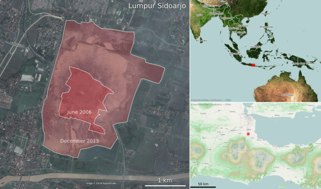
Lusi is the nickname of Lumpur Sidoarjo — 'the mud of Sidoarjo' — the giant mud volcano in the city of Sidoarjo, East Java, Indonesia. This week, Lusi is eight years old.

Google MapsBefore you read on, I recommend taking a look at it in Google Maps. Actually, Google Earth is even better — especially with the historical imagery. 

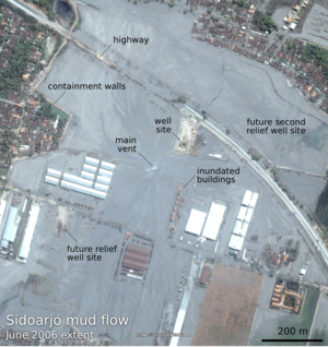
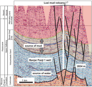
The mud flow was [may have been; see comments below — edit, 26 June 2014] triggered by the Banjar Panji 1 exploration well, operated by Lapindo Brantas, though the conditions may have been set up by a deadly earthquake. Mud loss events started in the early hours of 27 May 2006, seven minutes after the 6.2 Mw Yogyakarta earthquake that killed about 6,000 people. About 24 hours later, a large kick was killed and the blow-out preventer activated. Another 22 hours after this, while fishing in the killed well, mud, steam, and natural gas erupted from a fissure about 200 m southwest of the well. A few weeks after that, it was venting 180,000 m³ every day — enough mud to fill 72 Olympic swimming pools.

Thousands of years

In the slow-motion disaster that followed, as hot water from Miocene carbonates mobilized volcanic mud from Pleistocene mudstones, at least 15,000 people — and maybe as many as 50,000 people — were displaced from their homes. Davies et al. (2011) estimated that the main eruption may last 26 years, though recent sources suggest it is easing quickly. Still, during this time, we might expect 95–475 m of subsidence. And in the long term? 

By analogy with natural mud volcanoes it can be expected to continue to flow at lower rates for thousands of years. — Davies et al. (2011)

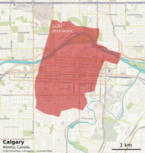
So we're only 8 years into a thousand-year man-made eruption. And there's already enough mud thrown up from the depths to cover downtown Calgary...

References and further reading

Quite a bit has been written about LUSI. The Hot Mud Flow blog tracks a lot of it. The National University of Singapore has a lot of satellite photographs, besides those you'll find in Google Earth. The Wikipedia article links to a lot of information, as you'd expect. The Interweb has a few others, including this article by Tayvis Dunnahoe in E&P Magazine. 

There are also some scholarly articles. These two are worth tracking down:

Davies, R, S Mathias, R Swarbrick and M Tingay (2011). Probabilistic longevity estimate for the LUSI mud volcano, East Java. Journal of the Geological Society 168, 517–523. DOI 10.1144/0016-76492010-129

Sawolo, N, E Sutriono, B Istadi, A Darmoyo (2009). The LUSI mud volcano triggering controversy: was it caused by drilling? Marine & Petroleum Geology 26 (9), 1766–1784. DOI 10.1016/j.marpetgeo.2009.04.002


The satellite images in this post are © DigitalGlobe and Google, captured from Google Earth, and are used here in accordance with their terms of use. The maps are © OpenStreetMap and licensed ODbL. The seismic section is from Davies et al. 2011 and © The Geological Society of London and is used here in accordance with their terms of use. The text of this post is © Agile Geoscience and openly licensed under the terms of CC-BY, as always!