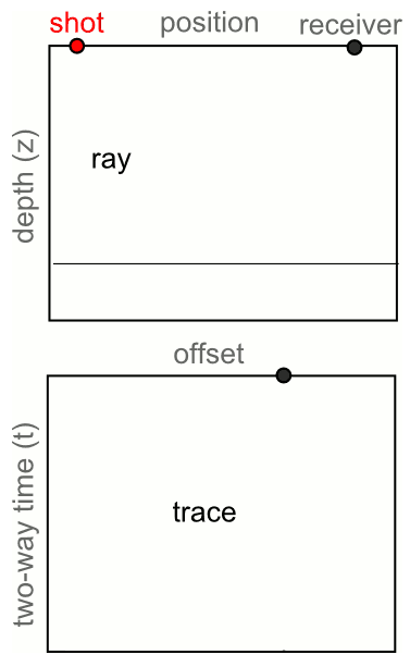
The power of stack

Multiplicity is a basic principle of seismic acquisition. Our goal is to acquite lots of traces—lots of spatial samples—with plenty of redundancy. We can then exploit the redundancy, by mixing traces, sacrificing some spatial resolution for increased signal:noise. When we add two traces, the repeatable signal adds constructively, reinforcing and clarifying. The noise, on the other hand, is spread evenly about zero and close to random, and tends to cancel itself. This is why you sometimes hear geophysicists refer to 'the power of stack'. 

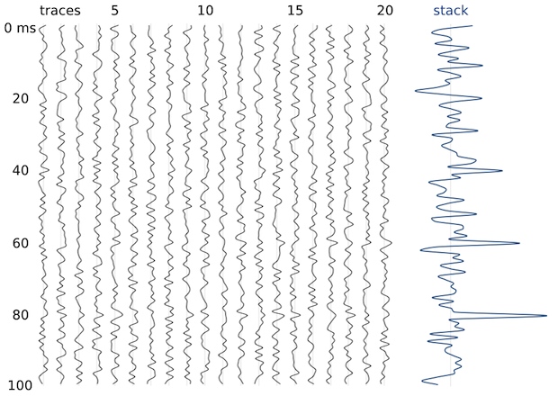
Here's an example. There are 20 'traces' of 100-digit-long sequences of random numbers (white noise). The numbers range between –1 and +1. I added some signal to samples 20, 40, 60 and 80. The signals have amplitude 0.25, 0.5, 0.75, and 1. You can't see them in the traces, because these tiny amplitudes are completely hidden by noise. The stacked trace on the right is the sum of the 20 noisy traces. We see mostly noise, but the signal emerges. A signal of just 0.5—half the peak amplitude of the noise—is resolved by this stack of 20 traces; the 0.75 signal stands out beautifully.

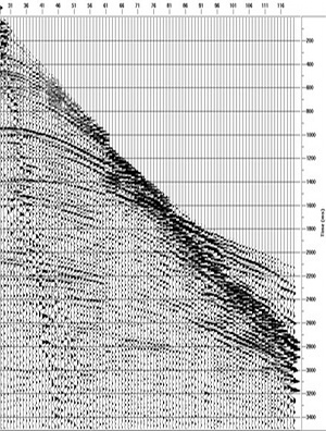
Here's another example, but with real data. This is part of Figure 3 from Liu, G, S Fomel, L Jin, and X Chen (2009). Stacking seismic data using local correlation. Geophysics 74 (2) V43–V48. On the left is an NMO-corrected (flattened) common mid-point gather from a 2D synthetic model with Gaussian noise added. These 12 traces each came from a single receiver, though in this synthetic case the receiver was a virtual one. Now we can add the 12 traces to get a single trace, which has much stronger signal, relative to the background noise, than any of the input traces. This is the power of stack. In the paper, Liu et al. improve on the simple sum by weighting the traces adaptively. Click to enlarge.

The number of traces available for the stack is called fold. The examples above have folds of 20 and 12. Geophysicists like fold. Fold works. Let's look at another example.

Above, I've made a single digit 1 with 1% opacity — it's almost invisible. If I stack two 2s, with a little random jitter, the situation is still desperate. When I have five digits, I can at least see the hidden image with some fidelity. However, if I add random noise to the image, a fold of 5 is no longer enough. I need at least 10, and ideally more like 20 images stacked up to see any signal. So it is for seismic data: to see through the noise, we need fold.

Now you know a bit about why we want more traces from the field, next time I'll look at how much those traces cost, and how to figure out how many you need. 

Thank you to Stuart Mitchell of Calgary for the awesome analogy for seismic fold.  

G is for Gather

When a geophysicist speaks about pre-stack data, they are usually talking about a particular class of gather. A gather is a collection of seismic traces which share some common geometric attribute. The term gather usually refers to a common depth point (CDP) or common mid-point (CMP) gather. Gathers are sorted from field records in order to examine the dependence of amplitude, signal:noise, moveout, frequency content, phase, and other attributes that are important for data processing and imaging. 

Common shot or receiver gather: Basic quality assessment tools in field acquistion. When the traces of the gather come from a single shot and many receivers, it is called a common shot gather. A single receiver with many shots is called a common receiver gather. It is very easy to inspect traces in these displays for bad receivers or bad shots. 

shot gatherImage: gamut.to.it CC-BY-NC-NDCommon midpoint gather, CMP: The stereotypical gather: traces are sorted by surface geometry to approximate a single reflection point in the earth. Data from several shots and receivers are combined into a single gather. The traces are sorted by offset in order to perform velocity analysis for data processing and hyperbolic moveout correction. Only shot–receiver geometry is required to construct this type of gather.

Common depth point gather, CDP: A more sophisticated collection of traces that takes dipping reflector geometry other subsurface properties into account. CDPs can be stacked to produce a structure stack, and could be used for AVO work, though most authors recommend using image gathers or CIPs [see the update below for a description of CIPs]A priori information about the subsurface, usually a velocity model, must be applied with the shot–receiver geometry in order to construct this type of gather. [This paragraph has been edited to reflect the update below].

Common offset gather, COFF: Used for basic quality control, because it approximates a structural section. Since all the traces are at the same offset, it is also sometimes used in AVO analysis; one can quickly inspect the approximate spatial extent of a candidate AVO anomaly. If the near offset trace is used for each shot, this is called a brute stack.

Variable azimuth gather: If the offset between source and receiver is constant, but the azimuth is varied, the gather can be used to study variations in travel-time anisotropy from the presence of elliptical stress fields or reservoir fracturing. The fast and slow traveltime directions can be mapped from the sinsoidal curve. It can also be used as a pre-stack data quality indicator. 

Check out the wiki page for more information. Are there any gather types or applications that we have missed?

Find other A to Z posts

News of the week

Dips from pics

Algeria foldsIn collaboration with the Geological Survey of Canada, Pangaea Software have built a very nifty tool, Orion, for computing dip from satellite images and digital elevation models. With these two pieces of data, and some assumptions about scale, it's possible to deduce the dip of strata without getting your boots muddy. Matt heard all about this tool from the GSC collaborator, Paul Budkewitsch, at the 3P Arctic conference in Halifax last week; here's their abstract

CGGV Trilobit nodeOcean bottom investment

CGGVeritas has made a commitment to manufacture 800 new Trilobit four-component deepwater nodes for seismic acquisition, to add to its existing pool. The device has three oriented accelerometers plus a hydrophone in addition to an onboard battery and recording system. This all-in-one design can be deployed on the seabed by most ROVs, making it easy to place near platforms and other infrastructure that towed streamer and cable systems cannot access. 

Arguably the industry leader in cableless systems is FairfieldNodal, who are already deploying more than a thousand nodes. It's great to see a big player like CGGVeritas coming to compete with this potentially transformative technology.

Update for Insight Earth

Colorado-based software company TerraSpark has just announced the release of Insight Earth 1.6, an integrated volume interpretation tool. Enhancements include a more interactive data import and export interface, improved velocity modeling, and upgrades to the automated fault extraction. In a January post, Evan highlighted an article by Stan Hammon of TerraSpark on the computational and psychological factors affecting intellegent design. It's inspired stuff.

Re-introducing SubSurfWiki

AgileWiki is now SubSurfWiki, at subsurfwiki.org. Please change your bookmarks! We felt that it was a little too Agile-centric and want to appear as open web-space for anything subsurface. We want it to grow, deepen and diversify, and above all be useful. So check it out and let us know if you have any feedback on utility, appearance and content.

More news... If you like this, check out previous news posts from Agile*

Orion is a trademark of Pangaea Software. Insight Earth is a trademark of TerraSpark. SubSurfWiki is a trademark of Agile Geoscience. The satellite image is copyright of Google. This regular news feature is for information only. We aren't connected with any of these organizations, and don't necessarily endorse their products or services.

News of the week

CCGVeritas moves towards a million channels

DSU1 receiverSercel, a subsidiary of CGGVeritas, has introduced new data transmission technology, Giga Transverse, an add-on to the 428XL land acquisition system. The technology increases the maximum channels per line from 10 000 to 100 000, and brings them a big step closer to the possiblity of one million channels on a single job. It will immediately benefit their UltraSeis offering for high-density point-receiver land acquisition. They also refreshed the DSU1 receiver (left), making it smaller and sharper. Young geophysicists must be salivating over the data they will be processing and interpreting in the decades to come.

Petrophysics coming to OpendTect

dGB has a built a comprehensive software suite for the seismic world, but OpendTect is a little light on petrophysics and log analysis. Not anymore! There's a new plugin coming to OpendTect, from Argentinian company Geoinfo: CLAS, or Computer Log Analysis Software. This will make the software attractive to a wider spread of the subsurface spectrum. dGB are on a clear path to creating a full-featured, deeply integrated platform. And OpendTect is open source, so petrophysicists may enjoy creating their own programs and plugins for working with well log data.

Petrel 2011 incorporates knowledge sharing

In Petrel, Schlumberger is introducing a multi-faceted knowledge environment for the entire spectrum of subsurface specialists. The announced improvements for the 2011 version include coordinate conversion for seismic data, better seismic flattening, more interpretation functions, and, most interesting of all, introduces the Studio™ environment. Geoscientists and engineers can search and browse projects, select data, and customize their screens by creating personal collections of often-used processes. It doesn't sound as interactive or social as the awaited Convofy for GeoGraphix, but it is good to see software companies thinking about large-scale, long-term knowledge issues, and it already exists!

Open source vizualization virtualization

High-end visualizaiton performance on a laptop... perhaps even a tablet! TurboVNC in action in the US government. Image: US Data Analysis & Assessment Center wiki.Australian E&P company Santos Ltd recently won the 2011 Red Hat Innovator of the Year award. From the award submission: "Santos has been burnt in the past by hanging its hat on proprietary solutions only to have them rendered uneconomical through being acquired by bigger fish. So for Santos, the move to open source—and to Red Hat—also proved to be a security blanket, as they could be assured that no one could walk in and take its solution away".  Borne out of an explosion of geo-computing costs, and their desire to push the limits of technology, the company sponsored the TurboVNC and VirtualGL projects. The result: users can interpret from anywhere using a standard issue laptop (with dual 24" monitors when at their desks), achieving better performance than traditional workstations. Great foresight! What are you doing about your geo-computing problems?

This regular news feature is for information only. We aren't connected with any of these organizations, and don't necessarily endorse their products or services. Petrel and Studio are trademarks of Schlumberger. Giga Transverse is a trademark of Sercel. Low res DSU1 image from Sercel marketing material.

More geophysics apps

Please welcome our latest app, Fold*, into the world. It is now available for free in the Android Market. This one is aimed at geophysicists planning land 3D seismic surveys. You provide some basic data about the geometry, and the tool computes fold in natural bins, and trace density per unit area. It also provides a qualitative description of what such a geometry might be good for (simple structure only, say, or high S:N or reflectivity areas). Read all about it in the wiki.

We have also put together a new page on this website, gathering news & info all our geoscience apps in one place. You will find it in the title bar above. Please share it with anyone you see using an Android™ phone or tablet!

 If you have a wish for an app, leave a comment or drop us a line!