News of the week

Some news and views from the world of geoscience this last fortnight.

Open source GIS on a thumb drive

If you ever wanted to get into open source geospatial software but didn't know where to start, check this out. Last month OSGeo, the open source geospatial foundation, released version 5 of their OSGeo-Live project. This is a bootable disk image containing 47 pieces of free software, including several full GIS, world maps, and quick-start guides. Amazing!

Probability and panic

The L'Aquila earthquake of April 2009 killed 308 people. Six seismologists are now on trial for manslaughter, not so much because they failed to predict the quake, but because they allegedly downplayed the risk of a severe event. Most geoscientists believe that we cannot predict earthquakes today; these seismologists are effectively accused of trying to predict a non-earthquake. We don't know, but suspect their intent was misinterpreted—always a danger when specialists communicate with non-specialists. There is no daily coverage of the trial that we are aware of, but there are occasional reports in the press. In this short video, Giustino Parisse explains why he is one of the plaintiffs.

Magical geobloggery

If you're new to blogs—maybe you got a tablet recently and are discovering how easy it is to read the web these days—you might not be aware that there's a lot of geology in the blogosphere. Finding writers you want to read isn't easy though. You could scroll down this page and look for our BLOGROLL for some leads, or head over to Highly Allochthonous and read the latest Accretionary Wedge, a regular meta-post. This month: practical advice for the lifelong learner. 

Communicating rocks

We recently learned of this terrific new book from University of Houston professor Peter Copeland (thanks to his colleague, Rob Stewart, for the tip!). We haven't actually got our hands on it yet, but the Amazon preview has whet our appetites for geo-communication tips galore. The publisher, Prentice Hall, has kept the price to a reasonable amount, close to $35. Get your copy now!

This regular news feature is for information only. We aren't connected with any of these organizations, and don't necessarily endorse their products or services. Public domain map image from the USGS. 

News of the week

A quick round up of geosciencey tech news at the end of a busy week at SEG.

Mmm, open source

Visualization company Kitware, makers of open source viz software Paraview, have released a new version of VTK, their toolkit for developers. Version 5.8 has new and improved Python wrappers and support for openGL inside documents. They are also offering free online courses for much of their technology. If you don't know their stuff, now's the time to check it out!

Real-time data toolbox

Twitter and geophysics? Maybe: they announced some open source goodness this week with their Storm library for real-time analysis of massive data streams. They developed it for analysing breaking news and global events, but we think it might have application in all kinds of real-time data processing problems like microseismic and production monitoring. Find the project on GitHub.

Not just another software company?

Dynamic Graphics, a small California company, caught our eye. Their low profile seems about to change, as their 'quantitative visualization' software looks ready to compete with anyone. Their focus on 4D and well-planning pits them against outfits like Transform Software, Down Under GeoSolutions, and of course all the usual suspects.

Learn Python!

Enthought are the leaders in scientific programming and especially support for Python, as well as on-demand development. They now offer a regular Python programming course just for geophysicists, and tour all over the world with it. The next edition is in Houston, 2–4 November. If you ever wanted to dabble with code, this is your chance: Python is easy to learn and very powerful.

This regular news feature is for information only. We aren't connected with any of these organizations, and don't necessarily endorse their products or services. Python is a trademark of the Python Software Foundation. ParaView and VTK are trademarks of Kitware. Storm is a trademark of Twitter, Inc.

Curvelets, dreamlets, and a few tears

Day 3 of the SEG Annual Meeting came and went in a bit of a blur. Delegates were palpably close to saturation, getting harder to impress. Most were no longer taking notes, happy to let the geophysical tide of acoustic signal, and occasional noise, wash over them. Here's what we saw.

Gilles Hennenfent, Chevron

I (Evan) loved Gilles's talk Interpretive noise attenuation in the curvelet domain. For someone who is merely a spectator in the arena of domain transforms and noise removal techniques, I was surprised to find it digestable and well-paced. Coherent noise can be difficult to remove independently from coherent signal, but using dyadic partitions of the frequency-wavenumber (f-k) domain, sectors called curvelets can be muted or amplified for reducing noise and increasing signal. Curvelets have popped up in a few talks, because they can be a very sparse representation of seismic data.

Speaking of exotic signal decompositions, Ru-Shan Wu, University of California at Santa Clara, took his audience to new heights, or depths, or widths, or... something. Halfway through his description of the seismic wavefield as a light-cone in 4D Fourier time-space best characterized by drumbeat beamlets—or dreamlets—we realized that we'd fallen through a wormhole in the seismic continuum and stopped taking notes.

Lev Vernik, Marathon

Lev dished a delicious spread of tidbits crucial for understanding the geomechanical control on hydraulic fracture stimulations. It's common practice to drill parallel to the minimum horizontal stress direction to optimize fracture growth away from the well location. For isotropic linear elastic fracture behaviour, the breakdown pressure of a formation is a function of the maximum horizontal stress, the vertical stress, the pore pressure, and the fracture toughness. Unfortunately, rocks we'd like to frack are not isotropic, and need to be understood in terms of anisotropy and inelastic strains.

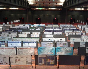
Lastly, we stopped in to look at the posters. But instead of being the fun-fest of awesome geoscience we were looking forward to (we're optimistic people), it was a bit of a downer and made us rather sad. Posters are often a bit unsatisfactory for the presenter: they are difficult to make, and often tucked away in a seldom-visited corner of the conference. But there was no less-frequented corner of San Antonio, and possibly the state of Texas, than the dingy poster hall at SEG this year. There were perhaps 25 people looking at the 400-or-so posters. Like us, most of them were crying.

More posts from SEG 2011.

Randomness and thin beds

Day 2 of the SEG Annual Meeting brought another 93 talks in the morning, and 103 in the afternoon, leaving us bewildered again: how to choose ten or so talks to see? (We have some ideas on this, more of which another day). Matt tried just sitting through a single session (well, almost), whereas Evan adopted the migrant approach again. These are our picks, just for you.

Stewart Trickett, Kelman

There has never been a dull or difficult talk from Stewart, one of Calgary's smartest and most thoughtful programmer–processors. He has recently addressed the hot-topic of 5D interpolation, a powerful process for making the dream of cheap, dense sampling a reality. Today, he explained why we need to now think about optimizing acquisition not for imaging, but for interpolation. And interpolation really likes pseudorandom sampling, because it helps negotiate the terms & conditions of Nyquist and avoid spatial aliasing. He went on to show a 3D subsampled then imaged three ways: remove every other shot line, remove every other shot, or remove a random shot from every pair of shots. All reduce the fold to 12% of the full data. The result: pseudorandom sampling wins every time. But don't panic, the difference in the migrated images was much smaller than in the structure stacks.

Gaynor Payton, ffA

In what could have been a product-focused marketing talk, Gaynor did a good job of outlining five easy-to-follow, practical workflows for interpreters working on thin beds. She showed frequency- and phase-based methods that exploit near-tuning, unresolved doublets in the waveform. A nice-looking bandwidth enhancement result was followed up with ffA's new high-resolution spectral decomposition we covered recently. Then she showed how negative spikes in instantaneous frequency can reveal subtle doublets in the waveform. This was extended with a skeletonized image, a sort of band-limited reflectivity display. Finally, she showed an interesting display of signed trace slope, which seemed to reveal the extent of just-resolved doublets quite nicely.

Scott Mackay, consultant

Scott MacKay shared some of his deep experience with depth imaging, but specially translated for interpreters. And this is only right: depth imaging is first and foremost an interpretive, iterative process, not a product. He gave some basic heuristics, guiding principles for interpreters. The first velocity model should be smooth—really smooth. Iterations should be only incrementally less smooth, 'creeping up' on the solution. Structure should get less, not more, complex with each step. Gathers should be flattish, not flat. Be patient, and let the data speak. And above all, Don't Panic. Always good advice.

More posts about SEG 2011.

Diffractions, Dust, and sub-Hertz imaging

Even the keenest geophysicist (and we are the keenest geophysicists) had to miss 96 presentations today. The first afternoon of talks comprised an impressive 104 talks in 13 sessions. If only 10% of talks are great, you might see one, and you would miss at least nine. Fortunately there are two of us, so we double our chances. These are our highlights.

Will Burnett, UT Austin

Diffractions, usually thought of as noise, emanate predominantly from faults and discontinuities. Will wants not to eliminate them but to use them as a complementary signal to boost imaging. His talk on diffraction velocity analysis described how, instead of picking an exact velocity model, a range of velocities are used to compute independent test images of diffraction events. Because the apex of a diffraction is the same no matter what velocity is applied, a stack of test images results in a concentration of the diffractor at the apex; the remaining events are stacked out. Blending this image with a reflection processed seismic yields a more vivid image. Also, this work was done using Madagascar... yay, open source!

Kris Pister, Dust Networks

The power of mobile devices is impressive, but Dust Networks can build an accelerometer with optical communication and a microcontroller in a 5 mm3 box. The autonomous sensors build a time-synchronized mesh protocol with channel-hopping (yeah, they do!), meaning you end up with an internet-like network that tolerates dead nodes and other failures. Now Dust build such networks of all kinds of sensors, of all sizes, in industrial applications, and surely will soon be appearing in a wellbore or seismic array near you. One to watch.

Rebecca Saltzer, ExxonMobil

Easily the most enthusiastic presentation of the day was a rip-roaring tale from Wyoming. ExxonMobil buried fifty-five low-frequency Guralp CMG3T seismometers at their LaBarge oil and gas field. The devices were arranged in a line pointing towards the Pacific, to ensure a good source of earthquakes: the source for this grand experiment. The P-waves they intended to image with have a dominant frequency of about 1 Hz, hence the seismometers, with their 0.08 to 50 Hz bandwidth. And image they did: the result was a velocity model with 500 m vertical resolution and good agreement with a 1000-well velocity model.

More posts about SEG 2011.

Frontiers at the Forum

The SEG Forum was the main attraction on Day 1 of the SEG Annual Meeting in San Antonio. Several people commented that the turnout was rather poor, however, with no more than 400 people sitting in the Lila Cockrell Theatre, even at the start. Perhaps the event needs more publicity. There was plenty of time for questions from the audience, all of which the panel discussed quite candidly.

David Lawrence, Executive VP of Exploration and Commercial at Shell gave, predictably, a rather dry corporate presentation. We understand how presentations like this get hijacked by lawyers and corporate communications departments, but wish more executives would stand up to their captors, especially for a short presentation to a technical audience. Despite his shackles, he had some eyebrow-raising technology to brag about: futuristic autonomous-vehicle marine nodes, and a million-channel sensor network, a project development they're developing with HP, of all companies.

Tim Dodson, Executive VP of Exploration at Statoil and once Matt's boss there, seemed similarly held captive by his corporation's presentation sanitizers. Saved by his charisma, Tim characterized Statoil's steady approach in exploration: deep pockets, patience, and being comfortable with risk. They seem to have the same approach to technology innovation, as Tim highlighted their Source Rock from Seismic method for characterizing source rocks and the high-resolution spectral decomposition technology we wrote about recently. Both projects took several years to develop, and have paid off in discoveries like Aldous and Skrugard respectively.

Susan Cunningham, Senior VP of Exploration at Noble Energy, spoke about her company's approach to frontier exploration. Despite her chronic use of buzz-phrases (innovative thinking, integrated objective assessment, partner of choice), Susan gave a spirited outlook on the human angles of Noble's frontier thinking. She discussed Noble's perseverance in the Eastern Mediterranean 8.5 Tcf Tamar discovery in the Levant Basin, and went on to describe Noble as a large company in a small company framework, but we're not sure what that means. Is it good?

Carl Trowell, president of WesternGeco and the youngest panelist, was the most engaging (and convincing) speaker. Shell's corporate communications people need to see presentations like this one: more powerful and trustable for its candid, personal, style. As you'd expect, he had deep insight into where seismic technolology is going. He lamented that seismic is not used enough in risk mitigation for frontier wells; for example, borehole seismic-while-drilling, imaged in the time it takes to trip out of the hole, can help predict pore pressure and other hazards in near-real-time. His forward-looking, energetic style was refreshing and inspiring.

It was a slightly dry, but basically up-beat, kick-off to the meeting. Some high-altitude perspective before we helicopter down to the nitty-gritty of the talks this afternoon.

Click here for all the posts about SEG 2011

News of the week

Dips from pics

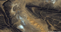
Algeria foldsIn collaboration with the Geological Survey of Canada, Pangaea Software have built a very nifty tool, Orion, for computing dip from satellite images and digital elevation models. With these two pieces of data, and some assumptions about scale, it's possible to deduce the dip of strata without getting your boots muddy. Matt heard all about this tool from the GSC collaborator, Paul Budkewitsch, at the 3P Arctic conference in Halifax last week; here's their abstract

CGGV Trilobit nodeOcean bottom investment

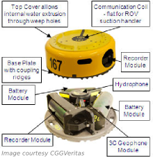
CGGVeritas has made a commitment to manufacture 800 new Trilobit four-component deepwater nodes for seismic acquisition, to add to its existing pool. The device has three oriented accelerometers plus a hydrophone in addition to an onboard battery and recording system. This all-in-one design can be deployed on the seabed by most ROVs, making it easy to place near platforms and other infrastructure that towed streamer and cable systems cannot access. 

Arguably the industry leader in cableless systems is FairfieldNodal, who are already deploying more than a thousand nodes. It's great to see a big player like CGGVeritas coming to compete with this potentially transformative technology.

Update for Insight Earth

Colorado-based software company TerraSpark has just announced the release of Insight Earth 1.6, an integrated volume interpretation tool. Enhancements include a more interactive data import and export interface, improved velocity modeling, and upgrades to the automated fault extraction. In a January post, Evan highlighted an article by Stan Hammon of TerraSpark on the computational and psychological factors affecting intellegent design. It's inspired stuff.

Re-introducing SubSurfWiki

AgileWiki is now SubSurfWiki, at subsurfwiki.org. Please change your bookmarks! We felt that it was a little too Agile-centric and want to appear as open web-space for anything subsurface. We want it to grow, deepen and diversify, and above all be useful. So check it out and let us know if you have any feedback on utility, appearance and content.

More news... If you like this, check out previous news posts from Agile*

Orion is a trademark of Pangaea Software. Insight Earth is a trademark of TerraSpark. SubSurfWiki is a trademark of Agile Geoscience. The satellite image is copyright of Google. This regular news feature is for information only. We aren't connected with any of these organizations, and don't necessarily endorse their products or services.

News of the week

The summer is, unbelievably, drawing in. While you've been gadding about in the sunshine, we've been scouring the geoscience and technology news — just for you! Here are some things that caught our eye in August. 

Spectral stuff from ffA

If you're a regular reader, you know we'll always cover a story about seismic frequency and resolution. A week ago, purveyors of high-tech seismic attributes ffA introduced HD Frequency Decomposition, or HDFD. As you might guess, HD stands for high definition, though it's not clear what that means in the context of seismic attributes. As is fairly normal with resolution-enhancing technology, the claims are eyebrow-raisingly bold:

...[we can] step beyond the resolution limitations of conventional frequency decomposition techniques.
Steve Purves, Technical Director, ffA

You can read about the technique in the nicely illustrated datasheet, but don't expect to find out how it works. I was disappointed to see that it doesn't even mention the type of decomposition; we assume it's some sort of scale-based approach (that is based on a wavelet, not Fourier, transform). Quiz them yourself at SEG next month in Booth C-1644.

By the way, if you're going to SEG and have a smart phone, think about keeping up with the buzz by following some chatterboxes on Twitter—@SEGAnnualMtg, @ParadigmLtd, @ESG_Solutions, @kwinkunks, and @EvanBianco. You can create and account and just follow the conversation, but it's more fun to join in!

More microseismic power for Canada

A good friend of Agile's recently went to work at Spectraseis, a seismic processing firm specializing in microseismic and reservoir monitoring in general. They just opened a Calgary office, so good luck to them in what is a pretty tight market (there must be 50 seismic processing shops in Calgary). The company also announced $3.6M of investment from Credit Suisse, so they are clearly on a roll.

Next gen knowledge management

Bayes' Theorem in neonRepsol, the Spanish oil company and supercomputing powerhouse, is rolling out some new knowledge sharing technology from Autonomy, a fast-growing UK company. There are two pieces: IDOL, an enterprise search engine, and Virage, a rich media management system. 

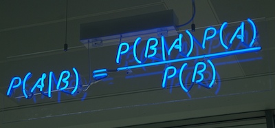
Autonomy is an awesome company. How do we know this? They have Bayes' Theorem up in neon lights. Yeah, Bayes' Theorem. 

Get geo-referenced maps faster

Elsevier is one of the giants of 'old school' publishing, but also one of the more innovative ones (have you seen their graphical abstracts?). They have just introduced an awesome-looking search site for exploration geoscientists, called Geofacets. It's a set of power tools for finding maps and figures, already georeferenced and ready for a GIS. It even includes IHS's global basins map to search more geologically, and includes what you need to know about rights and permissions. If your company has ScienceDirect access, which they probably do, then you should have immediate access.

Previous news posts from Agile*

HD Frequency Decomposition is a trademark of ffA, IDOL and Virage are trademarks of Autonomy, Geofacets is a trademark of Elesevier. Bayes' Theorem image is CC-BY-SA licensed by its creator mattbuck. This regular news feature is for information only. We aren't connected with any of these organizations, and don't necessarily endorse their products or services.

News of the week

We hope you're having a great summer. Our website has been quieter than usual this week, but we're busy building things—stay tuned. And we haven't done a news post for a few weeks, so here are some things that have caught our eye.

A new imaging paradigm

Lytro has begun what may be a revolution for photography with the light field camera, putting the choice of the focal point and depth of field in the hands of the viewer, not the photographer. Try it yourself: click on these examples to change the focal point of the images.

The radical new sensor works by not only capturing the intensity of light, but also its direction. This means the full visual field can be reconstructed. You can view the inspiring gallery of dynamic images or read more about the methods behind computational photography from Ian Hopkinson's blog post. The analogy to full wavefield imaging is obvious, but perhaps the most exciting story is not the technology, but the shift of control from imager (processor) to viewer (interpreter). 

Don't compress the data, expand the medium

Wolfram, makers of Mathematica among other things, are a deeply innovative bunch. This week they launched the Computable Document Format, or CDF, for interactive documents. These new documents could make reports, presentations, e-textbooks, and journal articles much more interesting. 

INT releases Geo Toolkit 4.2

Interactive Network Technologies, makers of the INTViewer interpretation software, have released a new version of its GeoToolkit, version 4.2. It's a proprietary C++ library for developers of geoscience software, and is used by many of the major exploration companies. New features include

  • Improved Seismic display with support for anti-aliasing, transparency, and image rotation
  • New indexed seismic data support for rapid access of large datasets
  • Enhancements to Chart libraries, including multiple selection within charts and ability to link charts.

TimeScale Creator gets a major upgrade

We have written before about this handy application from a Purdue consortium; it should be in every geoscientist's toolbox. Keep an eye out over the summer and fall for new datapacks (including Arctic Canada, Australia, NE Russia), and an all-new web version. Version 5 has some great enhancements:

  • A new data input format, and some limits on user data in the free version
  • Database and display improvements for humanoids, dinocycsts, and passive margins, plus new datapacks
  • Improved geographic interface, now with index maps

This regular news feature is for information only. We aren't connected with any of these organizations, and don't necessarily endorse their products or services.

News of the week

Happy Canada Day! Here is the news.

Scotian basin revivial?

Geologist–reporter Susan Eaton has a nice piece in the AAPG Explorer this month, explaining why some operators still see promise in the Scotian Basin, on Canada's Atlantic margin. The recent play fairway analysis mentioned in the report, however, is long overdue and still not forthcoming. When it is, we hope the CNSOPB and government promoters fully embrace openess and get more data into the public domain.

Yet another social network!

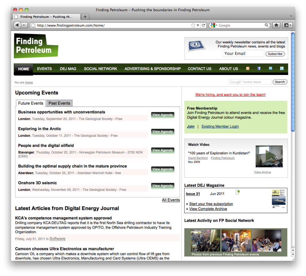
In the wake of LinkedIn's IPO, in which the first day of trading was over 500 times its net earnings in 2010, many other social networks are starting to pop up. Last month we mentioned SEG's new Communities. Finding Petroleum is a new social network, supported by the publishers of the Digital Energy Journal, aimed at oil and gas professionals. These sites are an anti-trust anomaly, since they almost have to be monopolies to succeed, and with so much momemtum carried by LinkedIn and Facebook, new entrants will struggle for attention. Most of the Commmunities in SEG seem to be essentially committee-based and closed, and LinkedIn micro-networks are getting chaotic, so maybe there's a gap here. Our guess is that there isn't.

The oil & gas blogosphere

Companies are increasingly turning to blogging and social media tools to expand their reach and promote their pursuits. Here are a couple of industry blogs that have caught our eye recently. If you are looking to read more about what's happening in subsurface oil and gas technology, these blogs are a good place to start.

If you use a microblogging service like Yammer, you may not know that you can also follow Twitter feeds. For example, here's a Twitter list of various companies in oil & gas.

Job security in geoscience

Historically, the oil and gas industry follows hot and cold (or, if you prefer, boom and bust) cycles, but the US Bureau of Labor Statistics predicts geoscience jobs will be increasingly in demand. A recent article from The Street reports on these statistics suggesting that the earth science sector is shaping up to be genuinely recession proof. If there is such a thing.

Agile* apps update

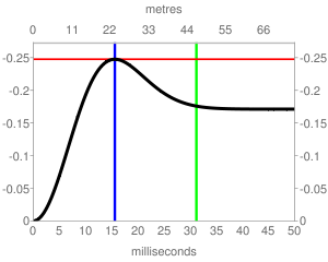
We're happy to report that all of Agile's apps have been updated in the last week, and we have a brand new app in the Android Market! The newest app, called Tune*, is a simple calculator for wedge modeling and estimating the amplitude tuning response of thin-beds, as shown here.

In our other apps, the biggest new feature is the ability to save cases or scenarios to a database on the device, so you can pull them up later.

Read more on our Apps page.

This regular news feature is for information only. Apart from Agile*, obviously, we aren't connected with any of these organizations, and don't necessarily endorse their products or services.