Lusi's 8th birthday
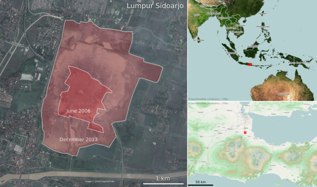
Lusi is the nickname of Lumpur Sidoarjo — 'the mud of Sidoarjo' — the giant mud volcano in the city of Sidoarjo, East Java, Indonesia. This week, Lusi is eight years old.

 Before you read on, I recommend taking a look at it in Google Maps. Actually, Google Earth is even better — especially with the historical imagery.
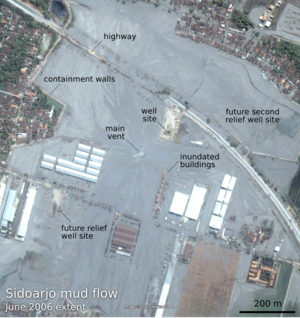
The mud flow was [may have been; see comments below — edit, 26 June 2014] triggered by the Banjar Panji 1 exploration well, operated by Lapindo Brantas, though the conditions may have been set up by a deadly earthquake. Mud loss events started in the early hours of 27 May 2006, seven minutes after the 6.2 Mw Yogyakarta earthquake that killed about 6,000 people. About 24 hours later, a large kick was killed and the blow-out preventer activated. Another 22 hours after this, while fishing in the killed well, mud, steam, and natural gas erupted from a fissure about 200 m southwest of the well. A few weeks after that, it was venting 180,000 m³ every day — enough mud to fill 72 Olympic swimming pools.
Thousands of years
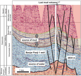
In the slow-motion disaster that followed, as hot water from Miocene carbonates mobilized volcanic mud from Pleistocene mudstones, at least 15,000 people — and maybe as many as 50,000 people — were displaced from their homes. Davies et al. (2011) estimated that the main eruption may last 26 years, though recent sources suggest it is easing quickly. Still, during this time, we might expect 95–475 m of subsidence. And in the long term?
By analogy with natural mud volcanoes it can be expected to continue to flow at lower rates for thousands of years. — Davies et al. (2011)
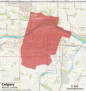
So we're only 8 years into a thousand-year man-made eruption. And there's already enough mud thrown up from the depths to cover downtown Calgary...
References and further reading
Quite a bit has been written about LUSI. The Hot Mud Flow blog tracks a lot of it. The National University of Singapore has a lot of satellite photographs, besides those you'll find in Google Earth. The Wikipedia article links to a lot of information, as you'd expect. The Interweb has a few others, including this article by Tayvis Dunnahoe in E&P Magazine.
There are also some scholarly articles. These two are worth tracking down:
Davies, R, S Mathias, R Swarbrick and M Tingay (2011). Probabilistic longevity estimate for the LUSI mud volcano, East Java. Journal of the Geological Society 168, 517–523. DOI 10.1144/0016-76492010-129
Sawolo, N, E Sutriono, B Istadi, A Darmoyo (2009). The LUSI mud volcano triggering controversy: was it caused by drilling? Marine & Petroleum Geology 26 (9), 1766–1784. DOI 10.1016/j.marpetgeo.2009.04.002
The satellite images in this post are © DigitalGlobe and Google, captured from Google Earth, and are used here in accordance with their terms of use. The maps are © OpenStreetMap and licensed ODbL. The seismic section is from Davies et al. 2011 and © The Geological Society of London and is used here in accordance with their terms of use. The text of this post is © Agile Geoscience and openly licensed under the terms of CC-BY, as always!
Thank you to Kristyo Adhi for pointing me to a couple more good references:
Satyana, AH, and Asnidar (2008). Mud diapirs and mud volcanocs in depressions of Java to Madura: Origins, nature, and implications to petroleum system. Proceedings of the Indonesian Petroleum Association's 32nd Annual Convention. IPA08–G–139. May 2008.
Mazzini, A, H Svensen, G Akhmanov, G Aloisi, S Planke, M Sørenssen, and B Istadi (2007). Triggering and dynamic evolution of the LUSI mud volcano, Indonesia. Earth and Planetary Science Letters 261, 375–388.


